IMAGES TAKEN NEAR TO
St. Pauls Road, CHELTENHAM, GL50 4EZ
Introduction
This page details the photographs taken nearby to St. Pauls Road, GL50 4EZ by members of the Geograph project.
The Geograph project started in 2005 with the aim of publishing, organising and preserving representative images for every square kilometre of Great Britain, Ireland and the Isle of Man.

There are currently over 7.5m images from over14,400 individuals and you can help contribute to the project by visiting https://www.geograph.org.uk
Image Map (Loading...)


Getting Data...Please wait
Leaflet Map data © OpenStreetMap
Images are licensed for reuse under creativecommons.org/licenses/by-sa/2.0
Notes
- Clicking on the map will re-center to the selected point.
- The higher the marker number, the further away the image location is from the centre of the postcode.
Image Listing (105 Images Found)
Images are licensed for reuse under creativecommons.org/licenses/by-sa/2.0
Image
Details
Distance
1
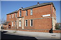
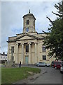
St Paul's Church Centre
The building was originally St Paul's School, which is still inscribed in stone over the middle lower window.
Image: © Terry Jacombs
Taken: 28 Mar 2012
0.03 miles
2
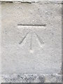
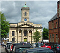
Ordnance Survey Cut Mark
This OS cut mark can be found on the SW angle of St Paul's Church. It marks a point 57.0417m above mean sea level.
Image: © Adrian Dust
Taken: 28 Jun 2015
0.04 miles
3
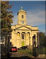
Church of St Paul, Cheltenham
"Built in a Greek Revival style, with details based on the Temple at Ilissus", Athens http://list.english-heritage.org.uk/resultsingle.aspx?uid=1387184&searchtype=mapsearch . "Constructed of pinkish-brown brick in English Garden Wall Bond, with ashlar facing to the west (actually south) front". This is indeed the south front, glowing in winter afternoon sun, and also shown in Image The church, seen here from across St Paul's Road, is listed grade II*. In front of it is a war memorial, also listed http://list.english-heritage.org.uk/resultsingle.aspx?uid=1419400&searchtype=mapsearch , as are the foreground railings and gates, contemporaneous with the church http://list.english-heritage.org.uk/resultsingle.aspx?uid=1387884&searchtype=mapsearch .
Image: © Derek Harper
Taken: 25 Oct 2014
0.04 miles

7
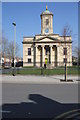
St Paul, St Paul's Road, Cheltenham
By John Forbes, 1829-31. Good effort with an Ionic portico, although the tower might offend purists. Grade II* listed.
Image: © Stephen Richards
Taken: 20 May 2015
0.04 miles
8
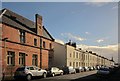
St Paul's Street North, Cheltenham
A terrace of 34 properties, seen from the junction with St Paul's Road. On the immediate left is Bramah House. In the distance is the octagonal spire; of St Gregory's church http://list.english-heritage.org.uk/resultsingle.aspx?uid=1387870&searchtype=mapsearch .
Image: © Derek Harper
Taken: 25 Oct 2014
0.05 miles
10
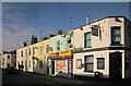
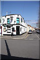
St Paul?s Road, Cheltenham
A terrace block between Hanover Street (right) and Hungerford Street. "Hamilton Place" survives as an old nameplate on the wall of the St Paul’s Tavern, formerly the Victoria, and an old street plan shows the name "Hamilton Place" covering the blocks between at least the next two streets as well.
Image: © Derek Harper
Taken: 25 Oct 2014
0.06 miles