IMAGES TAKEN NEAR TO
Barnwood, GLOUCESTER, GL4 3HR
Introduction
This page details the photographs taken nearby to GL4 3HR by members of the Geograph project.
The Geograph project started in 2005 with the aim of publishing, organising and preserving representative images for every square kilometre of Great Britain, Ireland and the Isle of Man.

There are currently over 7.5m images from over14,400 individuals and you can help contribute to the project by visiting https://www.geograph.org.uk
Image Map
Images are licensed for reuse under creativecommons.org/licenses/by-sa/2.0
Notes
- Clicking on the map will re-center to the selected point.
- The higher the marker number, the further away the image location is from the centre of the postcode.
Image Listing (29 Images Found)
Images are licensed for reuse under creativecommons.org/licenses/by-sa/2.0
Image
Details
Distance
1
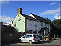
Chef and Brewer, Barnwood
Instant traditional pub.
Image: © Jonathan Thacker
Taken: 28 Jun 2014
0.01 miles
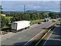
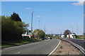
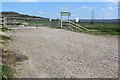
3
A417/A40 link road at Barnwood
Taken at the entrance to Sports and Leisure complex on the left
Image: © J Whatley
Taken: 22 Sep 2010
0.03 miles
4
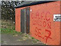
Graffiti, disused toilets, A40, Barnwood
C.A.F.C. refers to Charlton Athletic Football Club. B.N.P. means the British National Party, a political grouping. The artwork is a credit to both organizations.
Image: © Brian Robert Marshall
Taken: 5 Dec 2008
0.04 miles
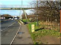
5
Alongside the A40 near Barnwood
The building in the background is (or was) a public convenience. It has been closed following the depredations of vermin.
Image: © Brian Robert Marshall
Taken: 5 Dec 2008
0.04 miles
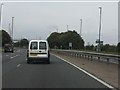
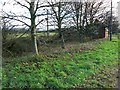
6
Footbridge over the A40, Barnwood
The footbridge is just inside the square. It takes a footpath from deep inside the Gloucester suburb away to the east where it joins a network of paths around and across Churchdown Hill.
Image: © Brian Robert Marshall
Taken: 5 Dec 2008
0.05 miles
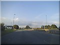
8
A40/A417 link road at entrance to Centre Severn
The slip road to the left leads to the Tenpin Bowling centre, Nuffield Health Club, Wheatstone Inn and Premier Travel Inn.
The footbridge over the road was built originally for cattle movement when the road was constructed. It therefore has a spiral and gradual incline. Now redundant due to the expansion of industrial units on the left of the road.
Image: © Richard Auckland
Taken: 18 Apr 2015
0.06 miles
9
A417/A40 link road at Barnwood - Entrance to Horsbere Brook Flood Prevention Scheme
Constructed in 2014 to alleviate the flooding downstream of the Horsbere as it narrowed through the housing estates on its way to the Severn Estuary.
Image: © Richard Auckland
Taken: 18 Apr 2015
0.06 miles
10
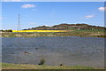
Horsbere Balancing pond Barnwood / Hucclecote border
This balancing pond, part of the Horsbere Brook flood alleviation scheme, was constructed in 2014.
Wildlife has now settled into the area again.
The hill in the distance is Churchdown Hill and the old footpath connecting Barnwood, Hucclecote and the Church at the top, can be seen winding its way up the hill.
Image: © Richard Auckland
Taken: 18 Apr 2015
0.06 miles