IMAGES TAKEN NEAR TO
Roselle Drive, GLOUCESTER, GL3 4GG
Introduction
This page details the photographs taken nearby to Roselle Drive, GL3 4GG by members of the Geograph project.
The Geograph project started in 2005 with the aim of publishing, organising and preserving representative images for every square kilometre of Great Britain, Ireland and the Isle of Man.

There are currently over 7.5m images from over14,400 individuals and you can help contribute to the project by visiting https://www.geograph.org.uk
Image Map (Loading...)


Getting Data...Please wait
Leaflet Map data © OpenStreetMap
Images are licensed for reuse under creativecommons.org/licenses/by-sa/2.0
Notes
- Clicking on the map will re-center to the selected point.
- The higher the marker number, the further away the image location is from the centre of the postcode.
Image Listing (13 Images Found)
Images are licensed for reuse under creativecommons.org/licenses/by-sa/2.0
Image
Details
Distance
1
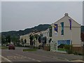
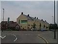
New homes at Coopers Edge
New development on Gloucester's eastern margin, with the Cotswold ridge in the background
Image: © Alan Howes
Taken: 22 May 2008
0.07 miles
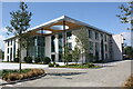
2
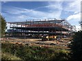
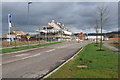
Site of New Ecclesiastical Insurance Head Office
Ecclesiastical Insurance Head Office under construction.
Image: © Colin Manton
Taken: 13 Sep 2019
0.10 miles
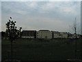
3
Development at Coopers Edge
The former Brockworth Airfield is undergoing redevelopment with business and retail premises along with residential housing.
Image: © Philip Halling
Taken: 26 Feb 2011
0.11 miles
4
Typhoon Way, Cooper's Edge
A large new-build estate on what was Brockworth airfield to the east of the city of Gloucester.
Image: © Jonathan Billinger
Taken: 31 Dec 2010
0.11 miles
5
New homes at Coopers Edge
Gloucester marches on East! Development is transforming this area.
Image: © Alan Howes
Taken: 22 May 2008
0.13 miles
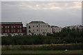
6
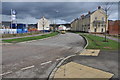
The eastern edge of Coopers Edge
In a year or two there will be a lot more homes in this part of Gloucester
Image: © Alan Howes
Taken: 22 May 2008
0.14 miles
7
Ecclesiastical Insurance, Gloucester
This is the new HQ of Ecclesiastical Insurance. At the time the photograph was taken it was still to be occupied. It is assumed that the Covid Pandemic caused a delay in occupation. It is located at Gambet Road, Brockworth, Gloucester.
Image: © Colin Manton
Taken: 17 Jul 2020
0.16 miles
8
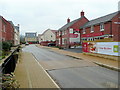
Beamont Walk, Apartments
Beamont Walk, Coopers Edge, Brockworth. Many of the roads were named after world war 2 pilots and aircraft as the estate is built on a former airfield.
Image: © Colin Manton
Taken: 27 Jul 2011
0.17 miles
9
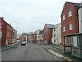
Housing development, Coopers Edge
The former Brockworth Airfield is being redeveloped with housing with the result that Gloucester is spreading out to the east of the M5 motorway.
Image: © Philip Halling
Taken: 26 Feb 2011
0.18 miles
10
Sapphire Way, Cooper's Edge
A large new-build estate on what was Brockworth airfield to the east of the city of Gloucester.
To the right is the Barratt Sales Office.
Image: © Jonathan Billinger
Taken: 31 Dec 2010
0.21 miles