IMAGES TAKEN NEAR TO
Cheltenham Road East, GLOUCESTER, GL2 9QF
Introduction
This page details the photographs taken nearby to Cheltenham Road East, GL2 9QF by members of the Geograph project.
The Geograph project started in 2005 with the aim of publishing, organising and preserving representative images for every square kilometre of Great Britain, Ireland and the Isle of Man.

There are currently over 7.5m images from over14,400 individuals and you can help contribute to the project by visiting https://www.geograph.org.uk
Image Map
Images are licensed for reuse under creativecommons.org/licenses/by-sa/2.0
Notes
- Clicking on the map will re-center to the selected point.
- The higher the marker number, the further away the image location is from the centre of the postcode.
Image Listing (5 Images Found)
Images are licensed for reuse under creativecommons.org/licenses/by-sa/2.0
Image
Details
Distance
1

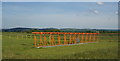
Innsworth - Cheltenham Road
Old A40 through Churchdown/Innsworth
Image: © Peter Randall-Cook
Taken: Unknown
0.07 miles
2
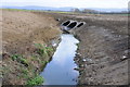
Norman's Brook
Norman's Brook viewed from the B4063, here the brook passes through part of the airfield of Gloucestershire Airport. The Gloucestershire Way did follow the brook here but has been slightly diverted to the west.
Image: © Philip Halling
Taken: 21 Jan 2012
0.11 miles
3
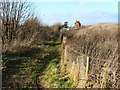
The Glevum Way, near Churchdown
The Way is classified as a footpath. There were wheeltracks indicating that pedestrians share it with motorcyclists. The building in the background is the office of a cattery and boarding kennel undertaking.
Image: © Brian Robert Marshall
Taken: 5 Dec 2008
0.13 miles
5
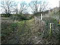
Glevum Way, near Churchdown
The Glevum Way was devised by the Gloucester Ramblers Group as part of the Ramblers Association Diamond Jubilee celebrations dating it to 1995. The footpath itself is rather older and is shown on my 1980s vintage Landranger map. The fence at the right is to stop people sneaking into the Gloucestershire Airfield.
Image: © Brian Robert Marshall
Taken: 5 Dec 2008
0.24 miles