IMAGES TAKEN NEAR TO
High Street, GLOUCESTER, GL2 7JB
Introduction
This page details the photographs taken nearby to High Street, GL2 7JB by members of the Geograph project.
The Geograph project started in 2005 with the aim of publishing, organising and preserving representative images for every square kilometre of Great Britain, Ireland and the Isle of Man.

There are currently over 7.5m images from over14,400 individuals and you can help contribute to the project by visiting https://www.geograph.org.uk
Image Map
Images are licensed for reuse under creativecommons.org/licenses/by-sa/2.0
Notes
- Clicking on the map will re-center to the selected point.
- The higher the marker number, the further away the image location is from the centre of the postcode.
Image Listing (49 Images Found)
Images are licensed for reuse under creativecommons.org/licenses/by-sa/2.0
Image
Details
Distance
1
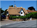
Thatched cottage in High Street, Saul
Possibly dating from c1500, restored in the 20th century. Grade II listed in 1986.
Image: © Jaggery
Taken: 27 May 2012
0.05 miles
2
Unusual type of electricity pole in High Street, Saul
Near Malthouse Farm.
Image: © Jaggery
Taken: 27 May 2012
0.11 miles
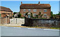
3
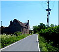
Malthouse Farm, Saul
Viewed from the B4071 High Street.
Image: © Jaggery
Taken: 27 May 2012
0.12 miles
4
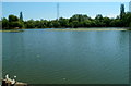
Gardeners Pool, Saul
GUAA (Gloucester United Anglers Association) fishing pool near Saul Farm. A nearby notice board states that fish must not be removed from the pool. Anyone taking fish will be prosecuted for stealing. Fishing club members are told to return carp to the water immediately after capture.
Image: © Jaggery
Taken: 27 May 2012
0.14 miles
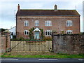
5
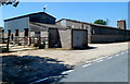
Saul Farm, Saul
Viewed from High Street Saul, south of the Church Lane junction.
Image: © Jaggery
Taken: 27 May 2012
0.14 miles
6
Saul Farm
The village is named after the willows or sallows (Salix) that were very common on this flat floodplain land before it was drained in the middle ages.
Image: © Jonathan Billinger
Taken: 5 Nov 2013
0.14 miles
7
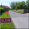
Slow - no road markings on High Street, Saul
Viewed in late May 2012.
Image: © Jaggery
Taken: 27 May 2012
0.16 miles
8

Bin day in Saul
Saul is named after the willows or sallows (Salix) that were very common on this flat floodplain land before it was drained in the middle ages.
View north along the High Street.
Image: © Jonathan Billinger
Taken: 5 Nov 2013
0.16 miles
9
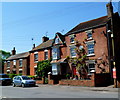
Steplike arrangement of High Street houses in Saul
Houses decrease in height with increasing distance from the corner of Church Lane.
Image: © Jaggery
Taken: 27 May 2012
0.17 miles
10
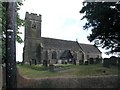
Saul church
I wonder if this village used to be called Paul... shame it's not on the way to a place called Damascus.
Image: © mym
Taken: 20 Jul 2003
0.19 miles