IMAGES TAKEN NEAR TO
Goodridge Avenue, GLOUCESTER, GL2 5EA
Introduction
This page details the photographs taken nearby to Goodridge Avenue, GL2 5EA by members of the Geograph project.
The Geograph project started in 2005 with the aim of publishing, organising and preserving representative images for every square kilometre of Great Britain, Ireland and the Isle of Man.

There are currently over 7.5m images from over14,400 individuals and you can help contribute to the project by visiting https://www.geograph.org.uk
Image Map
Images are licensed for reuse under creativecommons.org/licenses/by-sa/2.0
Notes
- Clicking on the map will re-center to the selected point.
- The higher the marker number, the further away the image location is from the centre of the postcode.
Image Listing (65 Images Found)
Images are licensed for reuse under creativecommons.org/licenses/by-sa/2.0
Image
Details
Distance
1
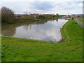
Dead-end section of canal, Gloucester
Viewed near Goodridge Avenue and the A430. This used to be part of the through route of the Gloucester and Sharpness Canal. It became a backwater during the Two Mile Cut project which straightened the course of the canal.
Image: © Jaggery
Taken: 13 Apr 2012
0.08 miles
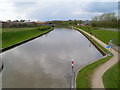
2
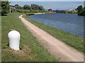
Gloucester & Sharpness Canal
The towpath approaching the stretch of the ship canal which was realigned a few years ago - see Image - to accommodate Netheridge swing bridge on the new A430. To the left of the bridge is a control tower.
Image: © Derek Harper
Taken: 23 Jun 2010
0.09 miles
3
Canal Junction
The arm to the right is disused as the Gloucester and Sharpness Canal was diverted with the construction of Netheridge Bridge.
Image: © Jonathan Thacker
Taken: 3 Oct 2023
0.09 miles
4
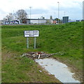
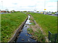
Daniels Brook Pollution Control Barrier, Quedgeley, Gloucester
Near this http://www.geograph.org.uk/photo/3957042 brook.
Image: © Jaggery
Taken: 13 Apr 2012
0.09 miles
5
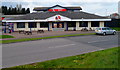
KFC in Quedgeley, Gloucester
Fast food outlet in Goodridge Avenue, Goodridge Trading Estate.
Image: © Jaggery
Taken: 13 Apr 2012
0.10 miles
6
Daniels Brook, Quedgeley, Gloucester
This part of the brook is between Goodridge Avenue on the left and the A430 on the right.
Image: © Jaggery
Taken: 13 Apr 2012
0.10 miles

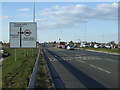
8
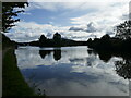
West along the canal from Netheridge Bridge, Gloucester
The Gloucester and Sharpness Canal viewed from the A430 on this http://www.geograph.org.uk/photo/4022009 swing bridge.
Image: © Jaggery
Taken: 13 Apr 2012
0.10 miles
10
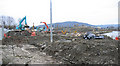
Canal being diverted, Two Mile Bend
The Two Mile Bend (from Gloucester Docks) is being straightened. A new moving bridge is being built to carry a new Gloucester bypass. Abutment behind the lamp post spoiling the view. There was no other choice of view through chink in fencing! This is said to be the largest canal diversion this century (so far)!
Image: © Peter Watkins
Taken: 29 Jan 2006
0.11 miles