IMAGES TAKEN NEAR TO
St. James Close, GLOUCESTER, GL2 4DN
Introduction
This page details the photographs taken nearby to St. James Close, GL2 4DN by members of the Geograph project.
The Geograph project started in 2005 with the aim of publishing, organising and preserving representative images for every square kilometre of Great Britain, Ireland and the Isle of Man.

There are currently over 7.5m images from over14,400 individuals and you can help contribute to the project by visiting https://www.geograph.org.uk
Image Map
Images are licensed for reuse under creativecommons.org/licenses/by-sa/2.0
Notes
- Clicking on the map will re-center to the selected point.
- The higher the marker number, the further away the image location is from the centre of the postcode.
Image Listing (33 Images Found)
Images are licensed for reuse under creativecommons.org/licenses/by-sa/2.0
Image
Details
Distance
1
Office Building former RAF Quedgeley
Most of this old RAF site will become housing in the near future
Image: © Peter Watkins
Taken: 3 Feb 2006
0.05 miles
2
Former RAF Quedgeley
A former administrative building can be seen in the background, this RAF site closed in 1995. It now awaits redevelopment.
Image: © Philip Halling
Taken: 16 Feb 2013
0.08 miles
3
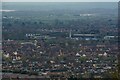
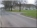
Gloucester : Quedgeley Scenery
Looking towards the suburbs of Quedgeley.
Image: © Lewis Clarke
Taken: 2 Apr 2023
0.09 miles
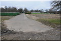
4

A38 from Quedgeley towards Gloucester
Looking NNE from the Naas Lane overbridge.
Image: © Jaggery
Taken: 22 Jan 2017
0.11 miles
5
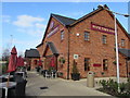
Rose Tree Farm, Quedgeley, Gloucester
Recently-built Farmhouse Inns Dining & Carvery in Kingsway Business Park viewed in January 2019.
Image: © Jaggery
Taken: 27 Jan 2019
0.11 miles
6
Rudloe Drive electricity substation, Quedgeley, Gloucester
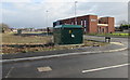
The dark green cabinet is an electricity substation. Its identifier is N7020256-1 KINGSWAY.
Kingsway Health Centre https://www.geograph.org.uk/photo/6035039 is in the background.
Image: © Jaggery
Taken: 27 Jan 2019
0.11 miles
7
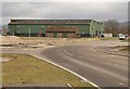
Buildings of former RAF Quedgeley
See also Image These green storage hangars, in use by businesses since RAF Quedgeley closed in 1995, are being demolished http://www.kingsway-business-park.co.uk/index.php/news/15-demolition-begins-a-new-development.html .
Image: © Derek Harper
Taken: 12 Mar 2010
0.11 miles
8
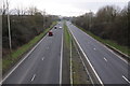
The A38 at Quedgeley
The A38 was rerouted along this then newly built dual carriageway around thirty years ago. The original A38 runs parallel to the west and is now the B4008.
Image: © Philip Halling
Taken: 16 Feb 2013
0.12 miles
9
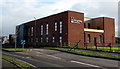
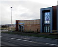
Kingsway Health Centre, Quedgeley, Gloucester
Recently-opened health centre viewed across Rudloe Drive in January 2019.
A July 2018 Google Earth View shows the building under construction.
Image: © Jaggery
Taken: 27 Jan 2019
0.13 miles
10
Badham Pharmacy, Rudloe Drive, Quedgeley, Gloucester
Part of the recently-opened Kingsway Health Centre https://www.geograph.org.uk/photo/6035039 viewed in January 2019.
A July 2018 Google Street View shows the health centre under construction.
Image: © Jaggery
Taken: 27 Jan 2019
0.13 miles