IMAGES TAKEN NEAR TO
Douglas Walk, TEWKESBURY, GL20 8UF
Introduction
This page details the photographs taken nearby to Douglas Walk, GL20 8UF by members of the Geograph project.
The Geograph project started in 2005 with the aim of publishing, organising and preserving representative images for every square kilometre of Great Britain, Ireland and the Isle of Man.

There are currently over 7.5m images from over14,400 individuals and you can help contribute to the project by visiting https://www.geograph.org.uk
Image Map
Images are licensed for reuse under creativecommons.org/licenses/by-sa/2.0
Notes
- Clicking on the map will re-center to the selected point.
- The higher the marker number, the further away the image location is from the centre of the postcode.
Image Listing (141 Images Found)
Images are licensed for reuse under creativecommons.org/licenses/by-sa/2.0
Image
Details
Distance
1
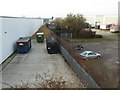
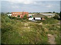
Ashchurch Industrial Estate
Ashchurch Industrial Estate viewed from the old railway bridge which used to cross the Ashchurch to Tewkesbury railway which closed in the early 1960s.
Image: © Philip Halling
Taken: 27 Dec 2016
0.06 miles
2
Industry and residential
Both part of the Ashchurch industrial and part of the Northway housing estate can be seen in this view from the old railway bridge which carries Northway Lane.
Image: © Philip Halling
Taken: 27 Dec 2016
0.06 miles
3
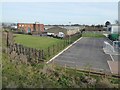
Northway Industrial Estate
Northway Industrial Estate viewed from the former railway bridge which used to cross the Ashchurch to Tewkesbury line which closed in the early 1960s. This same view was photographed back in 2006, see: Image The former railway line crossed what are now parking bays in the car park.
Image: © Philip Halling
Taken: 27 Dec 2016
0.09 miles
4
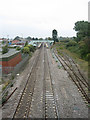
Ashchurch Station
Ashchurch Station, looking north from the road bridge on the A46. Built by the Birmingham and Gloucester Railway, it was formerly a junction with lines to Malvern on the left and Evesham on the right. A vestige of the latter line remains to serve the army depot.
Image: © Dave Bushell
Taken: 5 Oct 2005
0.10 miles
5
Northway Trading Estate
Looking from the bridge under which the former railway line to Tewkesbury (and Malvern) went. The converted brick building in the centre, the Power Station, is now offices. Much of the wasteland in the foreground was previously railway lines.
Image: © Jennifer Luther Thomas
Taken: 20 Sep 2006
0.10 miles
6
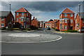
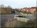
Recent housing developments Ashchurch
Image: © Philip Halling
Taken: 12 Apr 2008
0.11 miles
7
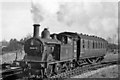
Ashchurch: train leaving for Tewkesbury
View SE, towards Ashchurch station; ex-Midland Ashchurch - Tewkesbury - Great Malvern line. This is the train depicted at Tewkesbury in Image], returning to Tewkesbury and Malvern on the same day. Hidden behind the engine is the loop line that connected the Tewkesbury branch with the line to Evesham across an unusual rail/rail level-crossing, as seen in other pictures of Ashchurch station.
Image: © Ben Brooksbank
Taken: 3 Nov 1951
0.12 miles
8
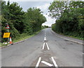
Northway Lane, Ashchurch
On July 29th 2017, a temporary yellow sign in front of a traffic lights warning
sign states that Northway Lane will be closed for one week starting 31.07.17.
Image: © Jaggery
Taken: 29 Jul 2017
0.13 miles
9
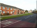
Houses on Northway Lane
Houses on Northway Lane in Northway.
Image: © Philip Halling
Taken: 27 Dec 2016
0.15 miles
10
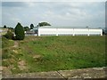
Wasteland/ Brownfield site?
Industrial unit next to Northway Trading Estate, beyond which lies the re-opened Ashchurch (for Tewkesbury) railway station. Previously this was the site of a railway junction, with lines running straight ahead towards Evesham and curving to the right to join the Birmingham to Bristol main line.
Image: © Jennifer Luther Thomas
Taken: 20 Sep 2006
0.15 miles