IMAGES TAKEN NEAR TO
High Street, TEWKESBURY, GL20 5LD
Introduction
This page details the photographs taken nearby to High Street, GL20 5LD by members of the Geograph project.
The Geograph project started in 2005 with the aim of publishing, organising and preserving representative images for every square kilometre of Great Britain, Ireland and the Isle of Man.

There are currently over 7.5m images from over14,400 individuals and you can help contribute to the project by visiting https://www.geograph.org.uk
Image Map
Images are licensed for reuse under creativecommons.org/licenses/by-sa/2.0
Notes
- Clicking on the map will re-center to the selected point.
- The higher the marker number, the further away the image location is from the centre of the postcode.
Image Listing (959 Images Found)
Images are licensed for reuse under creativecommons.org/licenses/by-sa/2.0
Image
Details
Distance
1
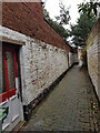
Stephens Alley, off the High Street, Tewkesbury
Image: © Jeff Gogarty
Taken: 23 Feb 2023
0.00 miles
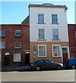
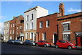
2
![Tewkesbury houses [62]](https://s2.geograph.org.uk/geophotos/06/89/06/6890602_cd8bddfc_120x120.jpg)
Tewkesbury houses [62]
Possibly originally two cottages, number 71 High Street is 17th century, refronted in the early 19th century. The front is brick, the rest timber framed, all under a slate roof. Listed, grade II, with details at: https://historicengland.org.uk/listing/the-list/list-entry/1201259
The market town of Tewkesbury is sited at the confluence of the River Severn and the River Avon, some 9 miles north of Gloucester, close to the border with Worcestershire. Founded in Saxon times, the town thrived and there are many medieval and Tudor buildings including Tewkesbury Abbey, bought by the townspeople to use as their parish church. One of the decisive battles of the Wars of the Roses was the Battle of Tewkesbury, which took place on 4 May 1471.
Image: © Michael Dibb
Taken: 18 May 2021
0.01 miles
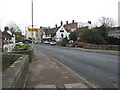
3
Turning on the A38 leaving Tewkesbury
Car registration VX52 TGO
Image: © Rob Purvis
Taken: 14 Jun 2009
0.01 miles
4
Stephens Alley, Tewkesbury
There are many named alleys in the centre of Tewkesbury. This view is across High Street towards Stephens Alley. The nameplate is on the wall above the black door near the car.
Image: © Jaggery
Taken: 14 Oct 2012
0.01 miles
5
![Tewkesbury houses [63]](https://s1.geograph.org.uk/geophotos/06/89/15/6891509_cf3ffe97_120x120.jpg)
Tewkesbury houses [63]
Number 72 High Street was built in the early or mid 19th century. Constructed in stuccoed brick, lined to simulate ashlar, with a rusticated ground floor, all under a slate roof. Listed, grade II, with details at: https://historicengland.org.uk/listing/the-list/list-entry/1355154
The market town of Tewkesbury is sited at the confluence of the River Severn and the River Avon, some 9 miles north of Gloucester, close to the border with Worcestershire. Founded in Saxon times, the town thrived and there are many medieval and Tudor buildings including Tewkesbury Abbey, bought by the townspeople to use as their parish church. One of the decisive battles of the Wars of the Roses was the Battle of Tewkesbury, which took place on 4 May 1471.
Image: © Michael Dibb
Taken: 18 May 2021
0.01 miles
6
![Tewkesbury houses [60]](https://s3.geograph.org.uk/geophotos/06/89/05/6890575_e52a59e5_120x120.jpg)
Tewkesbury houses [60]
Number 69 High Street is a house at the end of a row, built circa 1830s, and now used as offices. Constructed in rendered brick under a slate roof. https://historicengland.org.uk/listing/the-list/list-entry/1201258
The market town of Tewkesbury is sited at the confluence of the River Severn and the River Avon, some 9 miles north of Gloucester, close to the border with Worcestershire. Founded in Saxon times, the town thrived and there are many medieval and Tudor buildings including Tewkesbury Abbey, bought by the townspeople to use as their parish church. One of the decisive battles of the Wars of the Roses was the Battle of Tewkesbury, which took place on 4 May 1471.
Image: © Michael Dibb
Taken: 18 May 2021
0.01 miles
7
![Tewkesbury houses [61]](https://s2.geograph.org.uk/geophotos/06/89/05/6890578_7b79a536_120x120.jpg)
Tewkesbury houses [61]
This house at number 70 High Street is now used as offices. Built in the early 19th century in brick with a slate mansard roof, There are two later rear wings/ Listed, grade II, with details at: https://historicengland.org.uk/listing/the-list/list-entry/1355128
The market town of Tewkesbury is sited at the confluence of the River Severn and the River Avon, some 9 miles north of Gloucester, close to the border with Worcestershire. Founded in Saxon times, the town thrived and there are many medieval and Tudor buildings including Tewkesbury Abbey, bought by the townspeople to use as their parish church. One of the decisive battles of the Wars of the Roses was the Battle of Tewkesbury, which took place on 4 May 1471.
Image: © Michael Dibb
Taken: 18 May 2021
0.01 miles
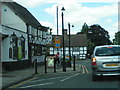
8
Ye Olde Black Bear, Tewkesbury
Taken from King John's Bridge. Ye Olde Black Bear claims to be Gloucestershire's oldest pub - dating back to 1308. Beyond the wall on the right is the riverside beer garden on the banks of the Avon.
Image: © Pauline E
Taken: 17 Nov 2007
0.01 miles
9
Buildings on Tewkesbury High Street
Buildings on the north end of Tewkesbury High Street. The building on the far left is premises of the solicitors, Moore Brown and Dixon.
Image: © Philip Halling
Taken: 10 Nov 2012
0.01 miles
10
![Tewkesbury houses [64]](https://s2.geograph.org.uk/geophotos/06/89/15/6891510_807ba242_120x120.jpg)
Tewkesbury houses [64]
Number 73 High Street was built in the early or mid 19th century. Constructed in brick with a slate roof. There is a through passage to the right and a rear wing. Listed, grade II, with details at: https://historicengland.org.uk/listing/the-list/list-entry/1282777
The market town of Tewkesbury is sited at the confluence of the River Severn and the River Avon, some 9 miles north of Gloucester, close to the border with Worcestershire. Founded in Saxon times, the town thrived and there are many medieval and Tudor buildings including Tewkesbury Abbey, bought by the townspeople to use as their parish church. One of the decisive battles of the Wars of the Roses was the Battle of Tewkesbury, which took place on 4 May 1471.
Image: © Michael Dibb
Taken: 18 May 2021
0.01 miles