IMAGES TAKEN NEAR TO
Lower Boulsdon, NEWENT, GL18 1JH
Introduction
This page details the photographs taken nearby to GL18 1JH by members of the Geograph project.
The Geograph project started in 2005 with the aim of publishing, organising and preserving representative images for every square kilometre of Great Britain, Ireland and the Isle of Man.

There are currently over 7.5m images from over14,400 individuals and you can help contribute to the project by visiting https://www.geograph.org.uk
Image Map
Images are licensed for reuse under creativecommons.org/licenses/by-sa/2.0
Notes
- Clicking on the map will re-center to the selected point.
- The higher the marker number, the further away the image location is from the centre of the postcode.
Image Listing (42 Images Found)
Images are licensed for reuse under creativecommons.org/licenses/by-sa/2.0
Image
Details
Distance
1
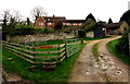
Lower Boulsdon Farm, Newent
On the west bank of Peacocks Brook at the southern edge of Newent.
Image: © Jaggery
Taken: 28 Dec 2015
0.02 miles
2
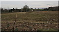
Late December in Lower Boulsdon, Gloucestershire
Viewed from the field gate here https://www.geograph.org.uk/photo/5792509 on December 28th 2015. Lower Boulsdon is near Newent.
Image: © Jaggery
Taken: 28 Dec 2015
0.03 miles
3
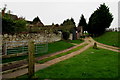
Path fork in Lower Boulsdon Farm, Newent
Viewed from Boulsden Lane. I'm uncertain of the correct spelling.
The lane is spelt Boulsden on the sign on the right here. http://www.geograph.org.uk/photo/4782464
The name at the farm entrance is Lower Boulsdon Farm.
One map I referred to added a third choice - it shows Lower Bouldson Farm, presumably a typo...
Image: © Jaggery
Taken: 28 Dec 2015
0.03 miles
4
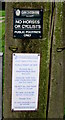
Public footpath only - no horses or cyclists, Newent
The Gloucestershire County Council Surveyors' notice is on a post
in front of this farmhouse http://www.geograph.org.uk/photo/4782792 at the southern edge of Newent.
Image: © Jaggery
Taken: 28 Dec 2015
0.04 miles
5
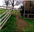
Wooden gate across a public footpath, Newent
Located near Lower Boulsdon Farm. http://www.geograph.org.uk/photo/4782704
The notice on the top bar of the gate shows DOGS TO BE ON LEADS.
The railings on the right are above Peacocks Brook.
Image: © Jaggery
Taken: 28 Dec 2015
0.04 miles
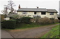
6
Brook Farm, Newent
The farmhouse is located at the southern edge of Newent, opposite Lower Boulsdon Farm. http://www.geograph.org.uk/photo/4782704
Image: © Jaggery
Taken: 28 Dec 2015
0.04 miles
7
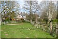
Footpath approaching Brook Farm
Footpath approaching Brook Farm to the south of Newent.
Image: © Philip Halling
Taken: 3 Apr 2022
0.05 miles
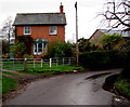
8
Burnside Cottage, Newent
On the east bank of Peacocks Brook, viewed from Boulsden Lane.
Image: © Jaggery
Taken: 28 Dec 2015
0.07 miles
9
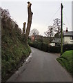
Pollarded trees, Boulsden Lane, Newent
A severe type of pruning, viewed in late December 2015.
Image: © Jaggery
Taken: 28 Dec 2015
0.07 miles
10
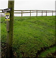
Gloucestershire Constabulary Rural Watch Area notice, Boulsden Lane, Newent
On a post near Burnside, a house on a bank of Peacocks Brook.
Image: © Jaggery
Taken: 28 Dec 2015
0.08 miles