1
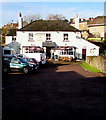
Hearts Of Oak To Let
Another pub on the market.
Image: © Des Blenkinsopp
Taken: 8 Feb 2015
0.04 miles
2
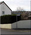
Approach to Drybrook from Morse Lane
Image: © Clint Mann
Taken: Unknown
0.04 miles
3
Boundary Stone, Morse Lane, Drybrook
Modern Forest of Dean boundary stone against a roadside wall. A survey before installing replacement stones described the stone as "in the wall". The look of it, there seems to be a similar stone behind, "in the wall".
Inscription: D. F. / 2016 / Nᴼ. 137
Milestone Society National ID: GL_DFDRYB137em
Image: © Mr Red
Taken: 4 Feb 2023
0.05 miles
4
Hearts of Oak, Drybrook
Pub set back 50 metres from Drybrook Road.
Image: © Jaggery
Taken: 11 Dec 2016
0.06 miles
5
Vales Butchers, Drybrook
Located at The Cross, Drybrook, on the corner of Whitehill Lane and Hawthorn Road.
Image: © Jaggery
Taken: 11 Dec 2016
0.06 miles
6
Signpost in the centre of Drybrook
Located on a corner of The Cross, crossroads in the centre of the village. Distances shown (in miles) are Cinderford 2½, Coleford 9, Puddlebrook ½, Wigpool 1½, Mitcheldean (via Stenders) 1¼.
Image: © Jaggery
Taken: 11 Dec 2016
0.06 miles
7
The Shop on the Cross, Drybrook
Located in Oak House, the Shop on the Cross is a charity shop run by the Love Drybrook Trust.
Image: © Jaggery
Taken: 11 Dec 2016
0.06 miles
8
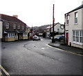
From Hawthorn Road towards The Cross, Drybrook
The Cross is the area in the centre of the village near the crossroads
of Drybrook Road, Whitehill Lane, High Street and Hawthorn Road.
Image: © Jaggery
Taken: 11 Dec 2016
0.07 miles
9
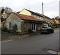
Rusty roof building in Drybrook
Former shop or other business premises viewed across Hawthorn Road in December 2016.
Image: © Jaggery
Taken: 11 Dec 2016
0.07 miles
10
Drybrook Road bus stop and shelter, Drybrook
On the west side of Drybrook Road, near the Hearts of Oak pub. http://www.geograph.org.uk/photo/5222141
Image: © Jaggery
Taken: 11 Dec 2016
0.07 miles


