IMAGES TAKEN NEAR TO
Grove Road, COLEFORD, GL16 8QH
Introduction
This page details the photographs taken nearby to Grove Road, GL16 8QH by members of the Geograph project.
The Geograph project started in 2005 with the aim of publishing, organising and preserving representative images for every square kilometre of Great Britain, Ireland and the Isle of Man.

There are currently over 7.5m images from over14,400 individuals and you can help contribute to the project by visiting https://www.geograph.org.uk
Image Map (Loading...)


Getting Data...Please wait
Leaflet Map data © OpenStreetMap
Images are licensed for reuse under creativecommons.org/licenses/by-sa/2.0
Notes
- Clicking on the map will re-center to the selected point.
- The higher the marker number, the further away the image location is from the centre of the postcode.
Image Listing (47 Images Found)
Images are licensed for reuse under creativecommons.org/licenses/by-sa/2.0
Image
Details
Distance
2
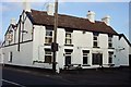
Bus shelter, Berry Hill
Opposite the King's Head pub in Grove Road.
Image: © Pauline E
Taken: 15 Apr 2008
0.02 miles
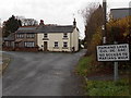
3
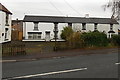
Row of houses near a former pub in Berry Hill
The 25 metres long row is near the corner of Grove Road and Coverham Road.
The edge of the former King's Head pub is on the left. http://www.geograph.org.uk/photo/4260258
Image: © Jaggery
Taken: 23 Nov 2014
0.03 miles
4
Gated bus shelter in Berry Hill
On the corner of Grove Road and Marians Lane. There is a spring on the gate which is intended to keep it closed, but it appears from the partly open gate that the spring has weakened somewhat. I wondered why a bus shelter needs a gate. Perhaps because of sheep in the area (this is the edge of the Forest of Dean where sheep roam freely in some locations) though I didn't see any sheep on roads or pavements in this area today.
Image: © Jaggery
Taken: 23 Nov 2014
0.03 miles
5

Former King's Head pub in Berry Hill
Viewed across Grove Road in late November 2014.
The building had more chimneys when still in use as a pub in April 2008. http://www.geograph.org.uk/photo/765545
Image: © Jaggery
Taken: 23 Nov 2014
0.04 miles
6
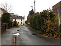
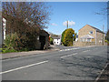
Marians Lane, Berry Hill
The sign on the corner of Grove Road on the right shows that this is not a through route.
Image: © Jaggery
Taken: 23 Nov 2014
0.06 miles
7
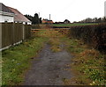
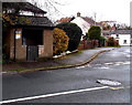
Gated access road to Beeches Farm, Berry Hill
Looking over one gate at the Grove Road end of the access road towards another gate.
Image: © Jaggery
Taken: 23 Nov 2014
0.06 miles
8
No access to Marians Walk from Marians Lane, Berry Hill
A cul-de-sac viewed from near the Grove Road junction.
Image: © Jaggery
Taken: 23 Nov 2014
0.07 miles

10
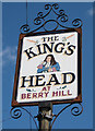
King's Head pub sign, Berry Hill
Near the car park entrance in Coverham Road.
Image: © Pauline E
Taken: 15 Apr 2008
0.08 miles