IMAGES TAKEN NEAR TO
Chepstow Road, COLEFORD, GL16 8LH
Introduction
This page details the photographs taken nearby to Chepstow Road, GL16 8LH by members of the Geograph project.
The Geograph project started in 2005 with the aim of publishing, organising and preserving representative images for every square kilometre of Great Britain, Ireland and the Isle of Man.

There are currently over 7.5m images from over14,400 individuals and you can help contribute to the project by visiting https://www.geograph.org.uk
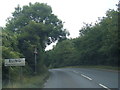
Image Map
Images are licensed for reuse under creativecommons.org/licenses/by-sa/2.0
Notes
- Clicking on the map will re-center to the selected point.
- The higher the marker number, the further away the image location is from the centre of the postcode.
Image Listing (42 Images Found)
Images are licensed for reuse under creativecommons.org/licenses/by-sa/2.0
Image
Details
Distance
1
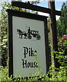
Pike House name sign, Sling
On the north side of Pike House Cottage. http://www.geograph.org.uk/photo/4557288
Image: © Jaggery
Taken: 5 Jul 2015
0.00 miles
2
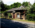
Pike House Cottage, Sling
Viewed across the B4228 at the edge of Sling, a village in the Forest of Dean District of west Gloucestershire.
Built as a (turn)pike toll house in the early 19th century, now a self-catering, 2 bedroom holiday let.
Image: © Jaggery
Taken: 5 Jul 2015
0.00 miles
3
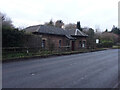
Toll House, Sling
Near the boundary with Milkwall, an important distinction in the Forest of Dean. People born within Dean Forest have rights unique to the enclave, notably to mine coal. On West side of the B4228. Originally served the Chepstow Turnpike Trust.
Milestone Society National ID: GL.CFD
Image: © Mr Red
Taken: 26 Jan 2022
0.01 miles
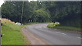
4
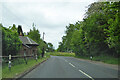
B4228 towards Coleford by Pike House, Sling
Apparently an old toll booth.
Image: © Robin Webster
Taken: 6 Jun 2023
0.02 miles
5
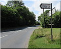
Signpost at the western edge of Sling
Alongside the B4228. Left for Sling, Ellwood and Parkend.
Ahead along the B4228 for Clearwell, Lydney and Chepstow.
Behind the camera for Coleford and Berry Hill.
Image: © Jaggery
Taken: 5 Jul 2015
0.02 miles
6
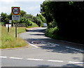
Please drive carefully in Sling
The National Speed Limit along the B4228 drops to 30mph along Milestone Walk
at the western edge of Sling, a village in the Forest of Dean District of west Gloucestershire.
Image: © Jaggery
Taken: 5 Jul 2015
0.04 miles
8
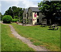
Path through the Miners Country Inn beer garden, Sling
From Milestone Walk to the B4228.
Image: © Jaggery
Taken: 5 Jul 2015
0.06 miles
10
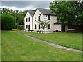
The Miners, Sling
The Miners Inn at Sling.
Image: © Philip Halling
Taken: 18 Aug 2020
0.07 miles