IMAGES TAKEN NEAR TO
Vicarage Gardens, COLEFORD, GL16 8FE
Introduction
This page details the photographs taken nearby to Vicarage Gardens, GL16 8FE by members of the Geograph project.
The Geograph project started in 2005 with the aim of publishing, organising and preserving representative images for every square kilometre of Great Britain, Ireland and the Isle of Man.

There are currently over 7.5m images from over14,400 individuals and you can help contribute to the project by visiting https://www.geograph.org.uk
Image Map (Loading...)


Getting Data...Please wait
Leaflet Map data © OpenStreetMap
Images are licensed for reuse under creativecommons.org/licenses/by-sa/2.0
Notes
- Clicking on the map will re-center to the selected point.
- The higher the marker number, the further away the image location is from the centre of the postcode.
Image Listing (273 Images Found)
Images are licensed for reuse under creativecommons.org/licenses/by-sa/2.0
Image
Details
Distance
1
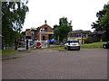
Coleford Station
The former station is now in use as a railway museum.
Image: © Dr Neil Clifton
Taken: 3 Jul 2015
0.01 miles
2
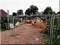
Fenced-off construction site, Old Station Way, Coleford
Viewed on September 4th 2016.
Image: © Jaggery
Taken: 4 Sep 2016
0.02 miles
3

Side view of School Cottages, Coleford
Now in residential use as a row of 5 cottages, the building was erected
in the 19th century as a school for the "education of the poor". http://www.geograph.org.uk/photo/1574410
http://www.geograph.org.uk/photo/3240318 to another view
Image: © Jaggery
Taken: 11 Dec 2011
0.02 miles
4
Old Station Road B4228 in Coleford
From the junction with Lords Hill
Image: © Martin Dawes
Taken: 16 Aug 2016
0.03 miles
5

End view of School Cottages, Coleford
Now in residential use as a row of 5 cottages, the building was erected
in the 19th century as a school for the "education of the poor". http://www.geograph.org.uk/photo/1574410
http://www.geograph.org.uk/photo/3240310 to another view.
Image: © Jaggery
Taken: 11 Dec 2011
0.03 miles
6
Warning - ramp, Old Station Way, Coleford
The ramp has been caused by the removal of the top layer of the road surface.
Image: © Jaggery
Taken: 4 Sep 2016
0.03 miles
7
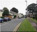
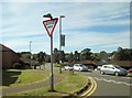
Up Lord's Hill, Coleford
Lord's Hill ascends from the B4228 Old Station Way towards Coalway.
Image: © Jaggery
Taken: 4 Sep 2016
0.04 miles
8
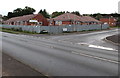
Bungalows under construction on a Coleford corner
The corner of Kings Meade and Old Station Way is fenced off in early September 2016.
The FOR SALE notice shows that these are 2-bedroom retirement bungalows.
Image: © Jaggery
Taken: 4 Sep 2016
0.04 miles
9
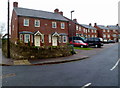
Lords Gate, Coleford
Houses in a cul-de-sac, viewed from Lords Hill. There is no apostrophe in the Lords Gate street name sign on the wall.
Image: © Jaggery
Taken: 11 Dec 2011
0.05 miles
10
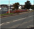
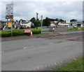
Distances from Coleford
The signs are alongside Old Station Way at the Lord's Hill junction.
Left for Lydney (7 miles) and Chepstow 13. Right for Coalway (½) and Parkend (3½).
The road past the fence on the right is towards Coleford town centre.
Image: © Jaggery
Taken: 12 Oct 2014
0.05 miles