IMAGES TAKEN NEAR TO
Cross Barn, COLEFORD, GL16 7PP
Introduction
This page details the photographs taken nearby to Cross Barn, GL16 7PP by members of the Geograph project.
The Geograph project started in 2005 with the aim of publishing, organising and preserving representative images for every square kilometre of Great Britain, Ireland and the Isle of Man.

There are currently over 7.5m images from over14,400 individuals and you can help contribute to the project by visiting https://www.geograph.org.uk
Image Map
Images are licensed for reuse under creativecommons.org/licenses/by-sa/2.0
Notes
- Clicking on the map will re-center to the selected point.
- The higher the marker number, the further away the image location is from the centre of the postcode.
Image Listing (146 Images Found)
Images are licensed for reuse under creativecommons.org/licenses/by-sa/2.0
Image
Details
Distance
1
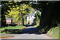
Cottages in a lane
Cottages in a lane at English Bicknor.
Image: © Philip Halling
Taken: 14 Oct 2012
0.03 miles
2
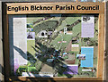
Heritage Trail information board, English Bicknor
This outlines a 45 minute circular walk, taking in Chepstow Wood and the restored Lime Kilns.
Car parking is available near the primary school.
Image: © Pauline E
Taken: 5 Oct 2007
0.05 miles
3
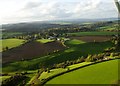
English Bicknor
Towards English Bicknor in the distance Symonds Yat and the Black mountains
Image: © Peter Randall-Cook
Taken: 31 Oct 2010
0.05 miles
4
English Bicknor
Bicknor Court Farm in the foreground.
Image: © Peter Randall-Cook
Taken: 30 Nov 2013
0.05 miles
5
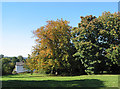
Trees on the turn in English Bicknor
Leaves are changing colour on this sycamore tree.
Image: © Pauline E
Taken: 5 Oct 2007
0.06 miles
7
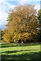
Horse chestnut tree
Horse chestnut tree in autumn colours near the school on English Bicknor.
Image: © Philip Halling
Taken: 14 Oct 2012
0.07 miles
8
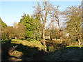
English Bicknor Castle
Today nothing much remains of English Bicknor Castle but these earthworks.
Image: © Stuart Wilding
Taken: 1 Dec 2008
0.09 miles
9
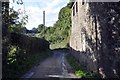
The road to Green Bottom
Oddly enough no mention of Green Bottom on the map but I'm sure that is the name used by locals. The road leads to a farm, a few houses and a holiday cottage.
Image: © Stuart Wilding
Taken: 16 Oct 2013
0.09 miles
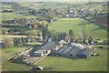
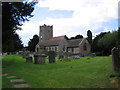
10
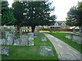
English Bicknor Church of England Primary School
The primary school at English Bicknor is very close-by to the parish church of St. Mary the Virgin itself. In fact, the school is viewed from the entrance to the previously-mentioned church.
Image: © Fabian Musto
Taken: 22 Dec 2018
0.09 miles