IMAGES TAKEN NEAR TO
Malvern Way, COLEFORD, GL16 7DZ
Introduction
This page details the photographs taken nearby to Malvern Way, GL16 7DZ by members of the Geograph project.
The Geograph project started in 2005 with the aim of publishing, organising and preserving representative images for every square kilometre of Great Britain, Ireland and the Isle of Man.

There are currently over 7.5m images from over14,400 individuals and you can help contribute to the project by visiting https://www.geograph.org.uk
Image Map
Images are licensed for reuse under creativecommons.org/licenses/by-sa/2.0
Notes
- Clicking on the map will re-center to the selected point.
- The higher the marker number, the further away the image location is from the centre of the postcode.
Image Listing (28 Images Found)
Images are licensed for reuse under creativecommons.org/licenses/by-sa/2.0
Image
Details
Distance
1
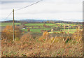
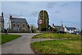
View from Edge End
Edge End is a small settlement of around 150 people which is situated on high ground on the northern edge of the Forest of Dean. This position gives long views over the Wye Valley towards Wales. The village has few facilities - a tin church and a recreation ground. View is taken from the end of a road known as Malvern Way.
Image: © Pauline E
Taken: 14 Nov 2008
0.04 miles
2
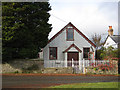
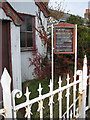
Edge End Methodist Church
Dwarfed by the nearby tree is the 'tin tabernacle' at Edge End. Situated on Chapel Walk near its junction with Malvern Way.
Image: © Pauline E
Taken: 14 Nov 2008
0.04 miles
3
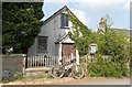
Edge End Methodist Chapel
Another photo of the now dis-used Methodist chapel at Edge End, showing signs of disrepair and encroaching ivy since Pauline's photo in 2008. Bees are busy in the roof space! One of my churches and chapels series - visited by bike from my home.
Image: © Andy Stott
Taken: 26 Apr 2020
0.05 miles
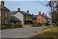
4
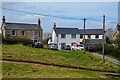
West Dean : Edge End - Houses
Houses at Edge End.
Image: © Lewis Clarke
Taken: 22 Mar 2023
0.05 miles
5
Information board at Edge End Methodist Church
See the church at Image
Image: © Pauline E
Taken: 14 Nov 2008
0.06 miles
6
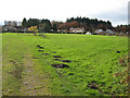
Playing field, Edge End
One of only two facilities in this small settlement on the edge of the Forest of Dean. The other being, Image
Image: © Pauline E
Taken: 14 Nov 2008
0.06 miles
7
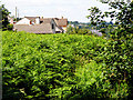
Edge End over the ferns
First view of Edge End as you walk along the ninewells spur footpath from the A4136.
Image: © Stuart Wilding
Taken: 21 Jul 2008
0.07 miles
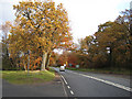
8
West Dean : Edge End - Malvern Way
Looking along Malvern Way off the A4136.
Image: © Lewis Clarke
Taken: 22 Mar 2023
0.07 miles
9
West Dean : Edge End - Chapel Walk
Chapel Walk off the A4136.
Image: © Lewis Clarke
Taken: 22 Mar 2023
0.07 miles
10
A4136 through the Forest of Dean
The left fork is Chapel Walk, Edge End.
Edge End is a small settlement of around 150 people which is situated on high ground on the northern edge of the Forest of Dean. The village has few facilities - a tin church and a recreation ground, and the busy A road forms its western boundary.
Image: © Pauline E
Taken: 14 Nov 2008
0.09 miles