IMAGES TAKEN NEAR TO
Robinson Road, GLOUCESTER, GL1 5DL
Introduction
This page details the photographs taken nearby to Robinson Road, GL1 5DL by members of the Geograph project.
The Geograph project started in 2005 with the aim of publishing, organising and preserving representative images for every square kilometre of Great Britain, Ireland and the Isle of Man.

There are currently over 7.5m images from over14,400 individuals and you can help contribute to the project by visiting https://www.geograph.org.uk
Image Map
Images are licensed for reuse under creativecommons.org/licenses/by-sa/2.0
Notes
- Clicking on the map will re-center to the selected point.
- The higher the marker number, the further away the image location is from the centre of the postcode.
Image Listing (103 Images Found)
Images are licensed for reuse under creativecommons.org/licenses/by-sa/2.0
Image
Details
Distance
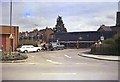
1
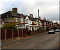
Robinson Road houses, Gloucester
Viewed from near the corner of King Edward's Avenue.
Image: © Jaggery
Taken: 6 Nov 2016
0.02 miles
2
Painswick Road Crossing
This view, looking east from Stroud Road at the junction with Tredworth Road show the site of the level crossing with former Midland Railway line through Gloucester. This line was plagued with a succession of level crossings and was eventually closed in the 1970s. All that can be seen today is the slight rise in the road (just the right of the further "diversion" sign) and the former railway cottage (the white building to the right of the picture). Compare with Image and Image
Image: © David Stowell
Taken: 13 Nov 2005
0.03 miles
3
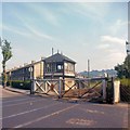
Painswick Road Crossing
The level crossing on former Midland Railway line through Gloucester. This line was plagued with a succession of level crossings and was eventually closed in the 1970s. In this 1968 view the signal box controlling the crossing can be seen along with one of the semaphore signals which were still in use at that time. Compare with Image (this picture was taken from by the further of the two yellow diversion signs in that photo) and Image
Image: © David Stowell
Taken: 19 Jul 1968
0.03 miles
4
Painswick Road Crossing gates
The crossing not long before closure of the former Midland Railway line from Gloucester Eastgate to Tuffley Junction. Very view visible changes have taken place since Image although the semaphore signals have been replaced by colour lights.
Image: © David Stowell
Taken: Unknown
0.03 miles
5
Train at Painswick Road crossing
The level crossing on former Midland Railway line between Gloucester Eastgate Station and Tuffley Junction. This line was plagued with a succession of level crossings and was eventually closed in the 1970s. Compare with Image, Image and Image
Image: © David Stowell
Taken: Unknown
0.03 miles
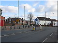
6
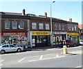
Four Stroud Road shops, Gloucester
Viewed from the Tredworth Road junction. From left to right are:
Bargain Booze, discount beers, wines, spirits, cigarettes.
New Garden, Chinese and Cantonese takeaway.
KM Reprographics, printing & copying services and drawing office supplies.
R.K. Convenience Store.
Image: © Jaggery
Taken: 13 Apr 2012
0.03 miles
7
Oasis Stroud Road Dental Practice, Gloucester
Oasis has more than 200 dental practices in England, Wales and Northern Ireland. This one is at 124 Stroud Road, Gloucester.
A street name sign partly hanging off the wall at the left edge of the building shows St Paul's Parade, an address which appears no longer to be in use.
Image: © Jaggery
Taken: 13 Apr 2012
0.03 miles
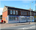
8
Pavilion Surgery, Gloucester
Family doctors' practice at 153a Stroud Road.
The shape of the building and the name of the surgery suggest that it may formerly
have been a cinema, but I have found no other evidence for this surmise.
Image: © Jaggery
Taken: 13 Apr 2012
0.03 miles
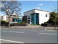
9
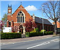
Gloucester Community Church, Gloucester
Located on the corner of Stroud Road and Robinson Road. http://www.geograph.org.uk/photo/2905472 to a side view
Originally named The Bible Christian Methodist Chapel, the foundation stones were laid in December 1903. The construction included a school, which opened in May 1904. The chapel opened in October 1904. In 1907 the chapel was renamed Stroud Road United Methodist Church. In 1955, it became St Luke's Methodist Chapel.
In 2008 it was sold by the Methodist Church, and is now Gloucester Community Church.
Image: © Jaggery
Taken: 13 Apr 2012
0.04 miles
10
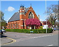
Side view of Gloucester Community Church, Gloucester
Located on the corner of Stroud Road and Robinson Road. http://www.geograph.org.uk/photo/2905118 to a front view.
Originally named The Bible Christian Methodist Chapel, the foundation stones were laid in December 1903. The construction included a school, which opened in May 1904. The chapel opened in October 1904. In 1907 the chapel was renamed Stroud Road United Methodist Church. In 1955, it became St Luke's Methodist Chapel.
In 2008 it was sold by the Methodist Church, and is now Gloucester Community Church.
Image: © Jaggery
Taken: 13 Apr 2012
0.04 miles