IMAGES TAKEN NEAR TO
The Hudnalls, LYDNEY, GL15 6RS
Introduction
This page details the photographs taken nearby to The Hudnalls, GL15 6RS by members of the Geograph project.
The Geograph project started in 2005 with the aim of publishing, organising and preserving representative images for every square kilometre of Great Britain, Ireland and the Isle of Man.

There are currently over 7.5m images from over14,400 individuals and you can help contribute to the project by visiting https://www.geograph.org.uk
Image Map
Images are licensed for reuse under creativecommons.org/licenses/by-sa/2.0
Notes
- Clicking on the map will re-center to the selected point.
- The higher the marker number, the further away the image location is from the centre of the postcode.
Image Listing (14 Images Found)
Images are licensed for reuse under creativecommons.org/licenses/by-sa/2.0
Image
Details
Distance
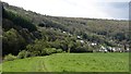
2
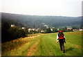
Llaneuddogwy / Llandogo
Cerddwr yn dilyn Llwybr Clawdd Offa. Yn y pellter mae pentre Llaneuddogwy.
Walker following the Offa's Dyke Path. In the distance is the village of Llandogo < Llaneuddogwy (Trans. church of St Euddogwy).
Image: © Alan Richards
Taken: 20 Jul 1997
0.13 miles
3
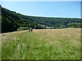
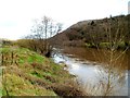
On the English bank of the Wye below Llandogo
A group of cyclists head northwards towards Bigsweir.
Image: © Jeremy Bolwell
Taken: 22 Jul 2012
0.13 miles
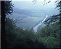
4
River Wye near Llandogo - 2
Looking north-east from Bargain Wood. Woodside House in the trees to the right of the river.
Image: © Trevor Rickard
Taken: Unknown
0.14 miles
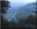
5
England/Wales border in the middle of the Wye, Llandogo
Several parts of the River Wye form the border between England and Wales. This view across the Wye from Llandogo, Wales to the English side is part of the lowest 16 miles (26 km) of the river from Redbrook to Chepstow where the midpoint of the river marks the border.
Image: © Jaggery
Taken: 4 Dec 2011
0.15 miles
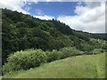

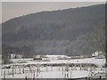
8
Llandogo
A view from the Wye with woodlands extending to a plateau just under 300m above. Cuckoo Wood shown here connects with a conifer plantation which extends as far as Trellech.
Image: © Richard Webb
Taken: 6 May 2012
0.18 miles
9
River Wye near Llandogo - 1
View north-east from the footpath in Bargain Wood. The outskirts of Llandogo village and the A466 on the left. Between the road and the river is the trackbed of the old Wye Valley Railway.
Image: © Trevor Rickard
Taken: Unknown
0.19 miles
10
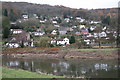
Llandogo and the River Wye
Llandogo viewed across the River Wye.
Image: © Philip Halling
Taken: 26 Nov 2005
0.20 miles