IMAGES TAKEN NEAR TO
Brains Green, BLAKENEY, GL15 4AP
Introduction
This page details the photographs taken nearby to Brains Green, GL15 4AP by members of the Geograph project.
The Geograph project started in 2005 with the aim of publishing, organising and preserving representative images for every square kilometre of Great Britain, Ireland and the Isle of Man.

There are currently over 7.5m images from over14,400 individuals and you can help contribute to the project by visiting https://www.geograph.org.uk
Image Map
Images are licensed for reuse under creativecommons.org/licenses/by-sa/2.0
Notes
- Clicking on the map will re-center to the selected point.
- The higher the marker number, the further away the image location is from the centre of the postcode.
Image Listing (22 Images Found)
Images are licensed for reuse under creativecommons.org/licenses/by-sa/2.0
Image
Details
Distance
1
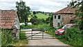
Miller's Farm, Brain's Green
Off Cinderford Road, near Blakeney.
Image: © Jonathan Billinger
Taken: 14 Jun 2021
0.01 miles
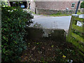
2
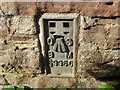
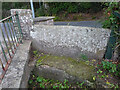
Ordnance Survey Flush Bracket S9960
This can be found on the wall of a house - a private dwelling - in Brian's Green.
For more detail see : http://www.bench-marks.org.uk/bm19076
Image: © Peter Wood
Taken: 16 Oct 2016
0.01 miles
3
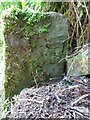
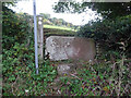
Stone Stile, Brains Green
On the Western side of Cinderford Road with the inscription facing North. In common with many places where the "Royal Forest of Dean" boundary crosses a road there is a plastic bollard with a green sticker bearing the legend "Statutory Boundary". This stone would have been on the other side of the road up to 1920, but at some time road widening (eg) necessitated a safer location on top of the West wall, and curiously set with the inscription facing North.
Inscription: D. [F.] / [Nᴼ. 12] / [1832]
Milestone Society National ID: GL_DFAWRE12em
Image: © Mr Red
Taken: 13 Jun 2023
0.04 miles
4
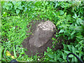
Boundary Stone, Loiterpin, Forest of Dean
Blakeney Hill, on the Eastern side of the road in the verge. Though lain and broken, it was in the exact location (1 m) of that predicted, and it has the same rounded top as many of the similar older boundary stones in the "Forest".
Milestone Society National ID: GL_DFAWRE13aem
Image: © Mr Red
Taken: 4 Oct 2022
0.09 miles
5

Stone Stile, Brains Green
An original "Royal Forest of Dean" Boundary Stone, 30 yds from Cinderford Road on a large triangle of grass and wayleave owned by Forestry England (ex Forestry Commission).
Inscription: D. F. / Nᴼ. 10 / 1832
Milestone Society National ID: GL_DFAWRE10em
Image: © Mr Red
Taken: 13 Jun 2023
0.13 miles
6
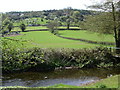
Farmland at the edge of the Forest of Dean
Looking across Forge Brook the farmland rises up towards the edge of the Forest of Dean. The road from Blakeney to Upper Soudley runs along the lower tree line.
Image: © Vincent Jones
Taken: 3 May 2006
0.13 miles
7
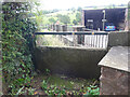
Stone Stile, Blakeney Hill
On Gloucestershire footpath DAW37 at Hewell's Farm, Cinderford Road. This looks West to road, the view East is Image
Image: © Mr Red
Taken: 4 Oct 2022
0.14 miles
8
Stone Stile, Blakeney Hill
On Gloucestershire footpath DAW37 at Hewell's Farm, Cinderford Road. This looks East, the view to the road is Image
Image: © Mr Red
Taken: 4 Oct 2022
0.14 miles
9
Stone Stile, Blakeney Hill
On Gloucestershire footpaths DAW38 & DAW39 from Cinderford Road opposite Hewell's Farm looking from the road. The view looking to the road is Image
Image: © Mr Red
Taken: 4 Oct 2022
0.14 miles
10
Stone Stile, Blakeney Hill
On Gloucestershire footpaths DAW38 & DAW39 from Cinderford Road, looking towards Hewell's Farm. The view from the road is Image
Image: © Mr Red
Taken: 4 Oct 2022
0.14 miles