IMAGES TAKEN NEAR TO
Lower Road, CINDERFORD, GL14 2TZ
Introduction
This page details the photographs taken nearby to Lower Road, GL14 2TZ by members of the Geograph project.
The Geograph project started in 2005 with the aim of publishing, organising and preserving representative images for every square kilometre of Great Britain, Ireland and the Isle of Man.

There are currently over 7.5m images from over14,400 individuals and you can help contribute to the project by visiting https://www.geograph.org.uk
Image Map
Images are licensed for reuse under creativecommons.org/licenses/by-sa/2.0
Notes
- Clicking on the map will re-center to the selected point.
- The higher the marker number, the further away the image location is from the centre of the postcode.
Image Listing (31 Images Found)
Images are licensed for reuse under creativecommons.org/licenses/by-sa/2.0
Image
Details
Distance
1
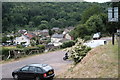
Site of Soudley Halt
The halt was opened in 1907, after the loss of some freight traffic on the GWR's Forest of Dean branch left some space in the schedule for it, and closed in 1958 after passenger traffic was lost to the far more convenient bus services. It was a fairly simple affair, consisting of a cinder platform and a corrugated iron shelter, and it was situated roughly where the black car is in the foreground. The area once occupied by the halt and the track is now the car park for the White Horse Inn. Immediately before Soudley, loco crews would have tackled the rigorous climb from sea level at Bullo, via two restrictive and lengthy tunnels, and the closed Soudley Halt was a popular place to stop and rebuild the fire, possibly due to the proximity of the White Horse! Taken to replicate a railway-era shot by Ben Ashworth.
Image: © John Winder
Taken: 4 Jun 2020
0.04 miles
3
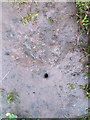
A rivet-less rivet bench mark on Soudley Bridge, Forest of Dean
This indistinct rivet bench mark is on the low east parapet on the older of the two bridges over Soudley Brook, Upper Soudley. The older bridge has now been by-passed providing safer access to the village hall. See also Image
Image: © John S Turner
Taken: 14 Jun 2019
0.08 miles
4
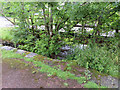
Soudley bridges over Soudley Brook
Part of the older of the two Soudley Bridges, with the more modern, and safer one behind the trees. There is a rivet bench mark cut into the low parapet in front of the camera: Image
Image: © John S Turner
Taken: 14 Jun 2019
0.08 miles
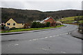
5
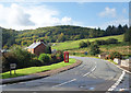
Top Road, Upper Soudley
A bit higher up the hillside than Lower Road.
Image: © Des Blenkinsopp
Taken: 24 Sep 2019
0.09 miles
6
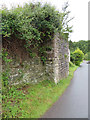
Former railway bridge support in Upper Soudley
The remaining bridge support that once carried the G.W.R. Forest of Dean Branch through Upper Soudley. There is an Ordnance Survey bench mark on the short face facing the camera: Image
Image: © John S Turner
Taken: 14 Jun 2019
0.09 miles
7
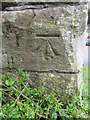
Bench mark in Upper Soudley, Forest of Dean
This Ordnance Survey bench mark is on the remaining bridge support that once carried the G.W.R. Forest of Dean Branch through Upper Soudley. See also: Image
Image: © John S Turner
Taken: 14 Jun 2019
0.09 miles
8
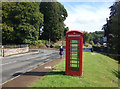
Phone Box, Top Road, Upper Soudley
In a prominent location on a neat bit of verge. Still quite red and with all its windows, and a phone inside. A rare specimen these days.
Image: © Des Blenkinsopp
Taken: 24 Sep 2019
0.09 miles
9
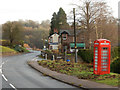
Top Road, Upper Soudley
Looking towards the White Horse Inn with a still functioning telephone box. There are plans to close the box, a controversial move because mobile reception is poor in this area.
Image: © Stephen McKay
Taken: 11 Dec 2016
0.10 miles
10
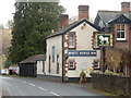
The White Horse Inn, Upper Soudley
Village pub on Church Road apparently noted for snail racing.
Image: © Stephen McKay
Taken: 11 Dec 2016
0.10 miles