IMAGES TAKEN NEAR TO
Hollydean, CINDERFORD, GL14 2LN
Introduction
This page details the photographs taken nearby to Hollydean, GL14 2LN by members of the Geograph project.
The Geograph project started in 2005 with the aim of publishing, organising and preserving representative images for every square kilometre of Great Britain, Ireland and the Isle of Man.

There are currently over 7.5m images from over14,400 individuals and you can help contribute to the project by visiting https://www.geograph.org.uk
Image Map (Loading...)


Getting Data...Please wait
Leaflet Map data © OpenStreetMap
Images are licensed for reuse under creativecommons.org/licenses/by-sa/2.0
Notes
- Clicking on the map will re-center to the selected point.
- The higher the marker number, the further away the image location is from the centre of the postcode.
Image Listing (84 Images Found)
Images are licensed for reuse under creativecommons.org/licenses/by-sa/2.0
Image
Details
Distance
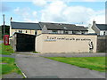
2
St. Stephen's Mission church, Bilson
An outpost of the town's main Anglican church - see; Image
Image: © Jonathan Billinger
Taken: 7 Aug 2009
0.08 miles
3
Towards Bilson Mission Cinderford
This road is unnamed. Instead, the groups of houses are named -
Hollydean on the left and Elmdean on the right.
A green tin church http://www.geograph.org.uk/photo/3655572 is in the background.
Image: © Jaggery
Taken: 16 Dec 2012
0.09 miles
4
St. Stephen's Mission church, Bilson
View from the west.
Image: © Jonathan Billinger
Taken: 7 Aug 2009
0.09 miles
5
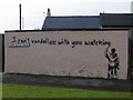
I can't vandalize...
...but I have got a sense of humor!
Upper Bilson Street, Cinderford.
Image: © Jonathan Billinger
Taken: 7 Aug 2009
0.09 miles
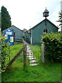
6
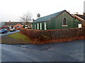
Bilson Mission, Cinderford
Part of the Church of England, St Stephen's Bilson Mission is located in Upper Bilson Road, Cinderford. The Cinderford Churches website records that the tin church was built in 1880 as a place of worship for local Gypsies. It was given to the parish and was moved here in 1900. A schoolroom was later added (on the right in this view) which is now used for midweek meetings.
Image: © Jaggery
Taken: 16 Dec 2012
0.09 miles
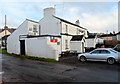
7
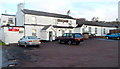
Upper Bilson Inn, Cinderford
The 40 metre long whitewashed building is on the corner of Valley Road and Seven Stars Road.
http://www.geograph.org.uk/photo/3262457 to a side view.
Image: © Jaggery
Taken: 16 Dec 2012
0.11 miles
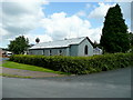
8
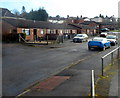
Rowandean bungalows, Cinderford
Viewed from the edge of Rowandean Court. http://www.geograph.org.uk/photo/3655583
Image: © Jaggery
Taken: 16 Dec 2012
0.11 miles
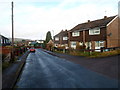
9
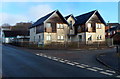
Rowandean Court Cinderford
Housing located about 70 metres south of the NW end of High Street.
Image: © Jaggery
Taken: 16 Dec 2012
0.12 miles
10
Side view of Upper Bilson Inn, Cinderford
The 40 metre long whitewashed building is on the corner of Valley Road and Seven Stars Road.
http://www.geograph.org.uk/photo/3262456 to a front view.
Image: © Jaggery
Taken: 16 Dec 2012
0.12 miles