IMAGES TAKEN NEAR TO
Foundry Road, CINDERFORD, GL14 2JU
Introduction
This page details the photographs taken nearby to Foundry Road, GL14 2JU by members of the Geograph project.
The Geograph project started in 2005 with the aim of publishing, organising and preserving representative images for every square kilometre of Great Britain, Ireland and the Isle of Man.

There are currently over 7.5m images from over14,400 individuals and you can help contribute to the project by visiting https://www.geograph.org.uk
Image Map
Images are licensed for reuse under creativecommons.org/licenses/by-sa/2.0
Notes
- Clicking on the map will re-center to the selected point.
- The higher the marker number, the further away the image location is from the centre of the postcode.
Image Listing (174 Images Found)
Images are licensed for reuse under creativecommons.org/licenses/by-sa/2.0
Image
Details
Distance
1
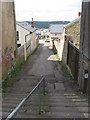
Steps off Market Street
Considering this is such a hilly place, I didn't come across many steps.
Image: © Pauline E
Taken: 17 Mar 2008
0.03 miles
2
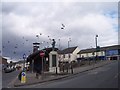
Cinderford Town Centre and War Memorial
Looking north just as the flock of birds flew over.
Image: © Bob Embleton
Taken: 5 Mar 2006
0.04 miles
3
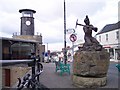
Cinderford Town Centre and the Miners' Memorial
On the memorial, sculpted by Antony Dufort, a plaque says that this was commissioned in the year 2000 as "A Tribute To The Miners Of The Forest Of Dean".
Image: © Bob Embleton
Taken: 5 Mar 2006
0.04 miles
4
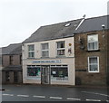
Cinderford Angling Shop
Located on the edge of the town centre at 3 Victoria Street.
Image: © Jaggery
Taken: 16 Dec 2012
0.05 miles
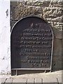
5
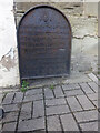
Commemorative Plate, Cinderford
On the wall of a house where Market and Victoria Streets concatenate.
Grade II Listed, details https://historicengland.org.uk/listing/the-list/list-entry/1186466.
Inscription:
V (crown) R
This road for the distance
of 1100 ↢ yards was made
at the expense of the crown
for the benefit of the
inhabitants and district
1897 - 8
E.Stafford Howard Esq
Commissioner
Philip Baylis Esq
Dep Surveyor
Milestone Society National ID: GL_CIND05cm
Image: © Mr Red
Taken: 15 Oct 2022
0.06 miles
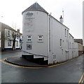
6

Cinderford Telephone Exchange, Glos
Situated in Station Street, this TE is of a standard design dating from the late 1960s, and has the code SSCIN. It provides telephone and broadband services to 5,180 residential and 363 non-residential premises in Cinderford plus Littledean, Ruspidge and Upper Soudley nearby. The numbering range of this TE is (01594) 82xxxx, the (01594) referring to the Lydney group of nine TEs, and its postcode is GL14 2JW.
Image: © David Hillas
Taken: 10 Jan 2018
0.06 miles
7
Corner of Victoria Street and Commercial Street, Cinderford
This view was taken from the point where Market Street behind the camera splits into Victoria Street (on the right) and Commercial Street. The building on the corner is the Soldiers and Sailors Club. http://www.geograph.org.uk/photo/3265938
Image: © Jaggery
Taken: 16 Dec 2012
0.06 miles
8
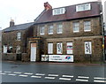
Flats available, Market Street, Cinderford
Conspicuous advertising shows that 1- and 2-bedroom flats are available here,
at the southern end of Market Street near the Victoria Street and Commercial Street junction.
Image: © Jaggery
Taken: 16 Dec 2012
0.06 miles
9
Victoria Street, Cinderford
Looking SSW along the road that for 1100 yards "was made at the expense of the crown for the benefit of the inhabitants and district" in 1897-8, Queen victoria's Diamond Jubilee.
Image: © Bob Embleton
Taken: 5 Mar 2006
0.07 miles
10
Victoria Street Plaque
At the northern end of Victoria Street explaining its connection with the Crown.
Image: © Bob Embleton
Taken: 5 Mar 2006
0.07 miles