IMAGES TAKEN NEAR TO
Woodlands Reach, CINDERFORD, GL14 2EN
Introduction
This page details the photographs taken nearby to Woodlands Reach, GL14 2EN by members of the Geograph project.
The Geograph project started in 2005 with the aim of publishing, organising and preserving representative images for every square kilometre of Great Britain, Ireland and the Isle of Man.

There are currently over 7.5m images from over14,400 individuals and you can help contribute to the project by visiting https://www.geograph.org.uk
Image Map (Loading...)


Getting Data...Please wait
Leaflet Map data © OpenStreetMap
Images are licensed for reuse under creativecommons.org/licenses/by-sa/2.0
Notes
- Clicking on the map will re-center to the selected point.
- The higher the marker number, the further away the image location is from the centre of the postcode.
Image Listing (89 Images Found)
Images are licensed for reuse under creativecommons.org/licenses/by-sa/2.0
Image
Details
Distance
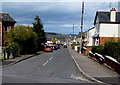
1
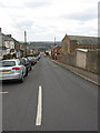
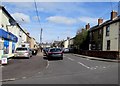
Flaxley Street, Cinderford
Pretty steep drop down past St. Anthony's Church. Looking west towards the forest.
Image: © Pauline E
Taken: 17 Mar 2008
0.05 miles
2
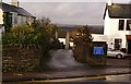
Mousel Lane, Cinderford, Forest of Dean
Darting off from Belle Vue Road in Cinderford is this little, somewhat curvaceous, lane. Surprisingly there is a closely packed string of dwellings on both sides of most of the lane as it tumbles down to merge with Woodside Street and Woodside Avenue into the junction of Church Road and Commercial Street.
Image: © Eric Soons
Taken: 11 Nov 2008
0.06 miles
3
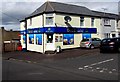
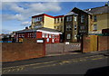
Best One in Cinderford
Convenience store on the corner of Flaxley Street and Pembroke Street.
Image: © Jaggery
Taken: 12 Apr 2015
0.06 miles
4
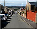
Flaxley Street, Cinderford
The eastern end of the street from the corner of Belle Vue Road.
Our Lady of Victories Catholic Church http://www.geograph.org.uk/photo/4425705 is on the right.
Image: © Jaggery
Taken: 12 Apr 2015
0.07 miles
5
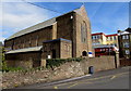
West side of Our Lady of Victories Catholic Church in Cinderford
Viewed across Flaxley Street. St Anthony's School & Nursery http://www.geograph.org.uk/photo/4425720 are in the background.
Image: © Jaggery
Taken: 12 Apr 2015
0.08 miles
6
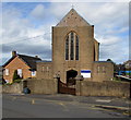
Our Lady of Victories Catholic Church in Cinderford
On the north side of Flaxley Street, near the corner of Abbey Street.
Image: © Jaggery
Taken: 12 Apr 2015
0.08 miles
7
Abbey Street, Cinderford
From Flaxley Street.
Image: © Jaggery
Taken: 12 Apr 2015
0.09 miles
8
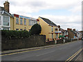
Saint Anthony's School, Cinderford
An independent school in Belle Vue Road.
Image: © Pauline E
Taken: 17 Mar 2008
0.10 miles
9
Pembroke Street, Cinderford
From Flaxley Street looking past a Best One convenience store http://www.geograph.org.uk/photo/4425828 on the left.
Image: © Jaggery
Taken: 12 Apr 2015
0.10 miles
10
St Anthony's School & Nursery, Cinderford
Viewed across Flaxley Street. Though the school has strong links with the adjacent Our Lady
of Victories Catholic Church, http://www.geograph.org.uk/photo/4425705 the school welcomes children of any faith, or none.
Image: © Jaggery
Taken: 12 Apr 2015
0.10 miles