1
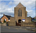
Our Lady of Victories Catholic Church in Cinderford
On the north side of Flaxley Street, near the corner of Abbey Street.
Image: © Jaggery
Taken: 12 Apr 2015
0.02 miles
2
Flaxley Street, Cinderford
The eastern end of the street from the corner of Belle Vue Road.
Our Lady of Victories Catholic Church http://www.geograph.org.uk/photo/4425705 is on the right.
Image: © Jaggery
Taken: 12 Apr 2015
0.02 miles
3
St Anthony's School & Nursery, Cinderford
Viewed across Flaxley Street. Though the school has strong links with the adjacent Our Lady
of Victories Catholic Church, http://www.geograph.org.uk/photo/4425705 the school welcomes children of any faith, or none.
Image: © Jaggery
Taken: 12 Apr 2015
0.02 miles
4
Flaxley Street electricity substation, Cinderford
The Central Networks electricity substation is in a wooden enclosure on the corner of Flaxley Street and Belle Vue Road. An Environmental Awareness label shows that the equipment is registered as PCB contaminated (less than 0.05% by weight). PCB = polychlorinated biphenyl.
Image: © Jaggery
Taken: 12 Apr 2015
0.03 miles
5
West side of Our Lady of Victories Catholic Church in Cinderford
Viewed across Flaxley Street. St Anthony's School & Nursery http://www.geograph.org.uk/photo/4425720 are in the background.
Image: © Jaggery
Taken: 12 Apr 2015
0.03 miles
6
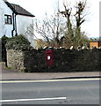
King George VI postbox in a Belle Vue Road wall, Cinderford
In need of a repaint in April 2015. Located here. http://www.geograph.org.uk/photo/4428374
Image: © Jaggery
Taken: 12 Apr 2015
0.04 miles
7
Wall postbox, Belle Vue Road, Cinderford
In April 2015, the King George VI postbox http://www.geograph.org.uk/photo/4428370 needs a repaint.
Image: © Jaggery
Taken: 12 Apr 2015
0.04 miles
8
Saint Anthony's School, Cinderford
An independent school in Belle Vue Road.
Image: © Pauline E
Taken: 17 Mar 2008
0.04 miles
9
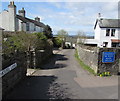
Eastern end of Mousel Lane, Cinderford
From Belle Vue Road. The lane is unsuitable for heavy goods vehicles.
Some maps show Mousell Lane. The name sign disagrees.
Image: © Jaggery
Taken: 12 Apr 2015
0.04 miles
10
Mousel Lane, Cinderford, Forest of Dean
Darting off from Belle Vue Road in Cinderford is this little, somewhat curvaceous, lane. Surprisingly there is a closely packed string of dwellings on both sides of most of the lane as it tumbles down to merge with Woodside Street and Woodside Avenue into the junction of Church Road and Commercial Street.
Image: © Eric Soons
Taken: 11 Nov 2008
0.05 miles


