IMAGES TAKEN NEAR TO
William Greening Place, GL14 1FD
Introduction
This page details the photographs taken nearby to William Greening Place, GL14 1FD by members of the Geograph project.
The Geograph project started in 2005 with the aim of publishing, organising and preserving representative images for every square kilometre of Great Britain, Ireland and the Isle of Man.

There are currently over 7.5m images from over14,400 individuals and you can help contribute to the project by visiting https://www.geograph.org.uk
Image Map
Images are licensed for reuse under creativecommons.org/licenses/by-sa/2.0
Notes
- Clicking on the map will re-center to the selected point.
- The higher the marker number, the further away the image location is from the centre of the postcode.
Image Listing (116 Images Found)
Images are licensed for reuse under creativecommons.org/licenses/by-sa/2.0
Image
Details
Distance
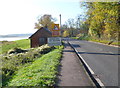
1
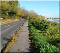
Southern boundary of Broadoak, Gloucestershire
A few metres beyond the 50mph speed limit sign is the Broadoak boundary sign, at the edge of the A48. Viewed from Newnham-on-Severn. The River Severn is visible on the right.
Image: © Jaggery
Taken: 6 Nov 2011
0.01 miles
4
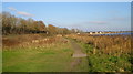
Riverside walk Newnham
Harvey and I can recommend the toilet facilities - human and canine.
Image: © David Robinson
Taken: 26 Dec 2008
0.05 miles
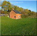
5
Salmon Fishing Centre and riverbank, Newnham
Image: © Gareth James
Taken: 22 Mar 2011
0.06 miles
6
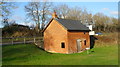
The salmon fishing centre Newnham
There are five different ways of catching salmon and all are practised near Newnham. If you want to know what they are you'll have to read that little plaque in front of the building. The A48 races past in the background.
Image: © David Robinson
Taken: 26 Dec 2008
0.06 miles
7
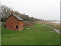
Grade II listed Fish House, Newnham
Also known as Newnham Salmon Hut. The small mid to late 19th century building is on an embankment on the west side of the River Severn, next to the A48.
Grade II listed in March 1987. The British Listed Buildings website states
"A very modest structure, but of historical interest through association with the Severn salmon fishing industry and one of the few remaining evidences."
The building is usually flooded several times a year by the highest spring tides, so the fishing equipment was stored upstairs. There are two drainage holes either side of the door to let flood water drain away. The grills prevented vermin entering the hut and damaging the equipment especially the nets. Brick flooring allowed river mud left by a flood to be cleaned out easily.
Image: © Jaggery
Taken: 6 Nov 2011
0.06 miles
8
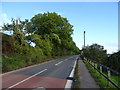
NE boundary of Newnham-on-Severn
The A48 leaves the hamlet of Broadoak and enters the village of Newnham-on-Severn.
The building next to the boundary sign is a Grade II listed former salmon hut. http://www.geograph.org.uk/photo/2685637
Image: © Jaggery
Taken: 6 Nov 2011
0.06 miles
9

Picnic area by the River Severn, Newnham
Image: © Jonathan Thacker
Taken: 17 Sep 2016
0.07 miles
10
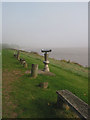
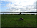
October Fog on the Severn
From the riverbank at Newnham-on-Severn. The sculptural steel telescope is the Millennium Marker, designed by Steve Bluett and erected to commemorate Passage 2000 when the two communities of Arlingham and Newnham were once more linked by ferry. For further information, see also Image
Image: © Pauline E
Taken: 11 Oct 2007
0.07 miles