IMAGES TAKEN NEAR TO
St. Marys Square, GLOUCESTER, GL1 2QT
Introduction
This page details the photographs taken nearby to St. Marys Square, GL1 2QT by members of the Geograph project.
The Geograph project started in 2005 with the aim of publishing, organising and preserving representative images for every square kilometre of Great Britain, Ireland and the Isle of Man.

There are currently over 7.5m images from over14,400 individuals and you can help contribute to the project by visiting https://www.geograph.org.uk
Image Map
Images are licensed for reuse under creativecommons.org/licenses/by-sa/2.0
Notes
- Clicking on the map will re-center to the selected point.
- The higher the marker number, the further away the image location is from the centre of the postcode.
Image Listing (1392 Images Found)
Images are licensed for reuse under creativecommons.org/licenses/by-sa/2.0
Image
Details
Distance
1
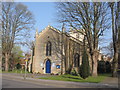
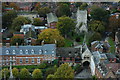
St Mary de Lode
Close to the cathedral, St Mary de Lode Church in Gloucester, probably the oldest parish church in the city. The word 'lode' comes from an old English word meaning ferry or water course.
Image: © David Roberts
Taken: 2 Apr 2009
0.01 miles
2
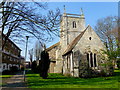
St. Mary de Lode, Gloucester
The word Lode is derived from an old English word meaning a water course or ferry. In this case it refers to a ferry that once crossed the river. At the time of building, there was a branch of the river to the west of the church, which no longer exists.
The Church is almost definitely the oldest parish church in the city, and according to local legend it was the burial place of Lucius, a king of Britain that established a bishopric in Gloucester in the second century.
The church lies to the west of the cathedral and is surrounded by blocks of apartments.
Image: © Jonathan Billinger
Taken: 24 Mar 2012
0.01 miles
3
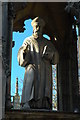
Statue of Bishop Hooper
Statue of Bishop Hooper who was a Protestant Reformer and was martyred in 1555 during the reign of Queen Mary.
Image: © Philip Halling
Taken: 23 Oct 2010
0.02 miles
4
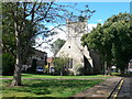
Church of St Mary de Lode, St Mary's Square, Gloucester
Parts of the church date back to 1190. http://www.imagesofengland.org.uk/Details/Default.aspx?id=472427&mode=adv
Image: © Eirian Evans
Taken: 20 Aug 2010
0.02 miles
5
Church of St Mary de Lode, Gloucester
The Church of St Mary de Lode and St Mary's gate viewed from the tower of Gloucester cathedral.
Image: © Philip Halling
Taken: 23 Oct 2010
0.02 miles
6
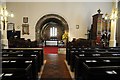
Interior of St Mary de Lode
The interior of St Mary de Lode church in Gloucester. The name lode refers to the church's proximity to the River Severn; in the past the river was nearer than it is today. Lode refers to a crossing point on the river; the name appears in several locations on the Severn. During the Civil War the church was used by Parliamentarian forces to imprison Royalist soldiers in 1643 and 1646.
Image: © Philip Halling
Taken: 13 Sep 2014
0.02 miles
7
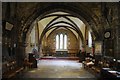
Chancel of St Mary de Lode
The Norman chancel of St Mary de Lode. The name, lode refers to the church's proximity to the River Severn, in the past the river was nearer than it is today. Lode refers to a crossing point on the river, the name appears in several locations on the Severn. During in the civil War the church was used by Parliamentarian forces to imprison Royalist soldiers in 1943 and 1646.
Image: © Philip Halling
Taken: 13 Sep 2014
0.02 miles
8
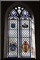
Window dedicated to Ivor Gurney
Stained glass window in St Mary de Lode church dedicated to local Great War poet, Ivor Gurney.
Image: © Philip Halling
Taken: 13 Sep 2014
0.02 miles
9
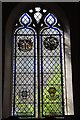
Window dedicated to Captain Robert Nairac GC
Stained glass window in St Mary de Lode church, dedicated to Captain Robert Nairac GC who was killed in the troubles in Northern Ireland in 1977.
Image: © Philip Halling
Taken: 13 Sep 2014
0.02 miles
10
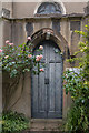
Doorway, St Mary's de Lode Church, Gloucester
Image: © Christine Matthews
Taken: 18 Jun 2016
0.02 miles