IMAGES TAKEN NEAR TO
Betony Close, WOTTON-UNDER-EDGE, GL12 8EJ
Introduction
This page details the photographs taken nearby to Betony Close, GL12 8EJ by members of the Geograph project.
The Geograph project started in 2005 with the aim of publishing, organising and preserving representative images for every square kilometre of Great Britain, Ireland and the Isle of Man.

There are currently over 7.5m images from over14,400 individuals and you can help contribute to the project by visiting https://www.geograph.org.uk
Image Map
Images are licensed for reuse under creativecommons.org/licenses/by-sa/2.0
Notes
- Clicking on the map will re-center to the selected point.
- The higher the marker number, the further away the image location is from the centre of the postcode.
Image Listing (35 Images Found)
Images are licensed for reuse under creativecommons.org/licenses/by-sa/2.0
Image
Details
Distance
1
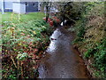
Little Avon River, Charfield
Viewed from Wotton Road (the B4058). For much of its length, as here, the river
forms the boundary between Gloucestershire http://www.geograph.org.uk/photo/3201345 and South Gloucestershire. http://www.geograph.org.uk/photo/3201323
The Little Avon is a tributary of the River Severn, into which it flows via Berkeley Pill.
Image: © Jaggery
Taken: 28 Oct 2012
0.09 miles
2
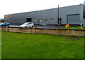
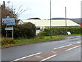
Renishaw, Charfield
Renishaw is an engineering company specialising in measurement, motion control, spectroscopy and precision machining. These recently-built premises are alongside Wotton Road (the B4058) on the east bank of the Little Avon River. The company has larger premises nearby in Wotton-under-Edge.
Image: © Jaggery
Taken: 28 Oct 2012
0.10 miles
3
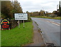
South Gloucestershire boundary, Charfield
The B4058 Wotton Road leaves Gloucestershire and enters South Gloucestershire
at the eastern approach to the village of Charfield.
The physical feature marking the county boundary here is the Little Avon River. http://www.geograph.org.uk/photo/3201372
Image: © Jaggery
Taken: 28 Oct 2012
0.11 miles
4
Gloucestershire boundary at the eastern edge of Charfield
The B4058 Wotton Road, heading away from the village of Charfield,
leaves South Gloucestershire and enters Gloucestershire.
The physical feature marking the county boundary here is the Little Avon River. http://www.geograph.org.uk/photo/3201372
Image: © Jaggery
Taken: 28 Oct 2012
0.11 miles
5
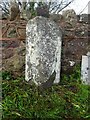
Old Boundary Stone, Charfield/Kingswood
In the centre of the North side of Watsome Bridge on the Wotton Road, B4058. It marks the ancient and current boundary of Charfield and Kingswood (Gloucestershire) parishes, also on the modern boundary between Gloucestershire county and South Gloucestershire unitary authority. It is triangular in cross-section, fairly typical of this area. Kingswood was formerly a detached part of Wiltshire that was incorporated into Gloucestershire by the Counties (Detached Parts) Act 1844.
Milestone Society National ID: GL_CHAKIN01pb
Image: © Mr Red
Taken: 23 Dec 2022
0.11 miles
6

Coal yard, Charfield
The metal gate is at the Wotton Road edge of the 75 metre long coal yard of Jones Bros.
Image: © Jaggery
Taken: 28 Oct 2012
0.12 miles
7
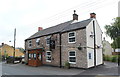
The Plough Inn, Wotton Road, Charfield, Gloucestershire 2014
Image: © Ray Bird
Taken: 11 Sep 2014
0.13 miles
8
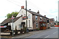
The Plough Inn, Wotton Road, Charfield, Gloucestershire 2014
Image: © Ray Bird
Taken: 11 Sep 2014
0.15 miles
9
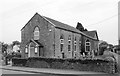
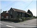
Congregational Church, Wotton Road, Charfield, Gloucestershire 2014
Image: © Ray Bird
Taken: 11 Sep 2014
0.15 miles