IMAGES TAKEN NEAR TO
Station Lane, WOTTON-UNDER-EDGE, GL12 8BP
Introduction
This page details the photographs taken nearby to Station Lane, GL12 8BP by members of the Geograph project.
The Geograph project started in 2005 with the aim of publishing, organising and preserving representative images for every square kilometre of Great Britain, Ireland and the Isle of Man.

There are currently over 7.5m images from over14,400 individuals and you can help contribute to the project by visiting https://www.geograph.org.uk
Image Map
Images are licensed for reuse under creativecommons.org/licenses/by-sa/2.0
Notes
- Clicking on the map will re-center to the selected point.
- The higher the marker number, the further away the image location is from the centre of the postcode.
Image Listing (69 Images Found)
Images are licensed for reuse under creativecommons.org/licenses/by-sa/2.0
Image
Details
Distance
1

Tytherington Railway Station
The station has seen no passengers for over 20 years but appears to be in remarkably good condition. An occasional goods train will still pass by on its way to Thornbury but not for much longer - the service will be withdrawn later in the year. However, that closure would only be temporary because stone traffic to Tytherington Quarry, about ½ mile behind me, would resume in 1972. At some stage the station building has been demolished - probably shortly after the 1966 closure.
Image: © Martin Tester
Taken: Unknown
0.03 miles
2
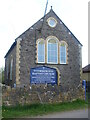
Tytherington Baptist Church
Dissenters have a long history in the village, going back to the seventeenth century. Official certificates were granted for formal meetings in various places (including houses and farms) as the Baptist movement gathered momentum around 1800. Here in Tytherington, a chapel was built on Stowell Hill Road but proved insufficient from 1842. A new church was built here on Itchington Road in 1884.
Image: © Neil Owen
Taken: 15 Apr 2021
0.04 miles
4
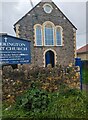
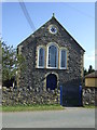
Tytherington Baptist Church, South Gloucestershire
Viewed from Itchington Road in Tytherington.
Image: © Jaggery
Taken: 24 Sep 2023
0.05 miles
5
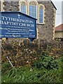
Information board outside Tytherington Baptist Church
In September 2023 text on the board outside the South Gloucestershire church includes
"In Covenant Relationship with St James Church" and
"Morning Worship & Sunday School at 10.30am"
Image: © Jaggery
Taken: 24 Sep 2023
0.05 miles
6
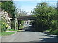
Railway crosses the road at Tytherington
Image: © Sarah Charlesworth
Taken: 7 Apr 2011
0.05 miles
7
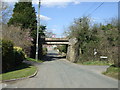
Railway bridge over Itchington Road
The old quarry line passes over the road in Tytherington. On the stonework near the grit bin is a benchmark - see Image
Image: © Neil Owen
Taken: 15 Apr 2021
0.06 miles
8
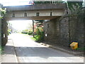
Railway bridge over Itchington Road, Tytherington
Image: © JThomas
Taken: 2 Apr 2013
0.06 miles
9
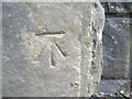
Benchmark on Itchington Road railway bridge
Dating from the mid twentieth century, this benchmark is listed in the Benchmark Database: https://www.bench-marks.org.uk/bm91186 . See Image] for a wider view.
Image: © Neil Owen
Taken: 15 Apr 2021
0.07 miles
10
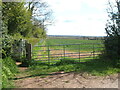
The footpath from Southlands
The footpath uses the field right beside the railway embankment.
Image: © Neil Owen
Taken: 15 Apr 2021
0.07 miles