IMAGES TAKEN NEAR TO
Byron Road, DURSLEY, GL11 4QA
Introduction
This page details the photographs taken nearby to Byron Road, GL11 4QA by members of the Geograph project.
The Geograph project started in 2005 with the aim of publishing, organising and preserving representative images for every square kilometre of Great Britain, Ireland and the Isle of Man.

There are currently over 7.5m images from over14,400 individuals and you can help contribute to the project by visiting https://www.geograph.org.uk
Image Map
Images are licensed for reuse under creativecommons.org/licenses/by-sa/2.0
Notes
- Clicking on the map will re-center to the selected point.
- The higher the marker number, the further away the image location is from the centre of the postcode.
Image Listing (9 Images Found)
Images are licensed for reuse under creativecommons.org/licenses/by-sa/2.0
Image
Details
Distance
1
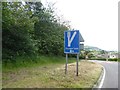
Sign for the second escape lane on Whiteway (A4135)
Image: © David Smith
Taken: 15 Jun 2018
0.06 miles
2
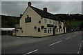
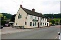
New Inn, Woodmancote
The New Inn in Woodmancote in Dursley.
Image: © Philip Halling
Taken: 5 Sep 2009
0.09 miles
4
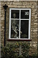
Looking through the window...
An unusual sight in the window of a house in Dursley.
Image: © Philip Halling
Taken: 5 Sep 2009
0.12 miles
5
New Inn (1), 82-84 Woodmancote Road, Dursley, Glos
Two bar public house, with beer garden.
Image
Image: © P L Chadwick
Taken: 25 Jul 2021
0.17 miles
6
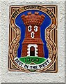
New Inn (2) - WCA brewery plaque, 82-84 Woodmancote Road, Dursley, Glos
The New Inn is one of many pubs in Gloucestershire that at one time sold West Country Ales, and still retains the WCA ceramic plaque. This brand eventually became part of the Whitbread empire, and around 1967 they discontinued the provision of these plaques. The one at the New Inn is immediately to the left of the main entrance.
Image
Image: © P L Chadwick
Taken: 25 Jul 2021
0.17 miles
7
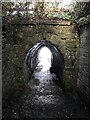
Unusual bridge or tunnel over the footpath
Image: © don cload
Taken: 21 Jan 2021
0.20 miles
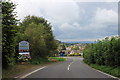
8
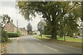
Woodmancote, Dursley
This is the A4136, with a small park on the right, by the junction with a road to Cambridge Avenue. The left turn is Hermitage Drive.
Image: © Derek Harper
Taken: 27 Oct 2014
0.23 miles
9
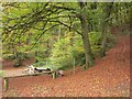
Twinberrow Woods
From bridleway CDU 73/1, looking along bridleway CDU 70/3, which is shown as coming to a halt after less than 200 metres near an old pit.
Image: © Derek Harper
Taken: 27 Oct 2014
0.24 miles