IMAGES TAKEN NEAR TO
Rosebery Road, DURSLEY, GL11 4PU
Introduction
This page details the photographs taken nearby to Rosebery Road, GL11 4PU by members of the Geograph project.
The Geograph project started in 2005 with the aim of publishing, organising and preserving representative images for every square kilometre of Great Britain, Ireland and the Isle of Man.

There are currently over 7.5m images from over14,400 individuals and you can help contribute to the project by visiting https://www.geograph.org.uk
Image Map
Images are licensed for reuse under creativecommons.org/licenses/by-sa/2.0
Notes
- Clicking on the map will re-center to the selected point.
- The higher the marker number, the further away the image location is from the centre of the postcode.
Image Listing (27 Images Found)
Images are licensed for reuse under creativecommons.org/licenses/by-sa/2.0
Image
Details
Distance
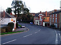
1
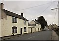
Woodmancote, Dursley
The A4136 heads towards the centre of Dursley. It's a grey day.
Image: © Derek Harper
Taken: 27 Oct 2014
0.08 miles
2
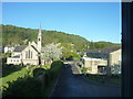
St Marks Church Vizard Close Woodmancote
Stinchcombe Hill is behind the Church and Dominates the area of Dursley
Image: © richard ellis
Taken: 1 May 2010
0.08 miles
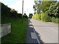
3
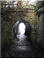
Unusual bridge or tunnel over the footpath
Image: © don cload
Taken: 21 Jan 2021
0.10 miles
4
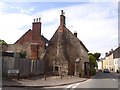
Cottage with external stone chimney, Dursley
At the end of Fort Lane; older maps suggest that there was another building between the junction and the cottage
Image: © David Smith
Taken: 15 Jun 2018
0.12 miles
5
The Carpenters Arms, Dursley
Pub on Uley Road on the edge of Dursley. (There's no apostrophe on the sign so I haven't introduced one here.) Opposite it is a small hardware shop.
Image: © David Gruar
Taken: 20 Jan 2007
0.13 miles
6
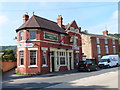
Carpenters Arms, Dursley
Pub at 32 Uley Road, near the corner of Rosebery Road.
Image: © Jaggery
Taken: 21 Jul 2012
0.13 miles
7
Highfields Approach, Dursley
The large street name sign shows that Highfields Approach leads to First Avenue,
Second Avenue, Third Avenue, Fourth Avenue, School Road and Rosebery Park.
This way also leads to Dursley Primary School. The shortest route is via Third Avenue.
Image: © Jaggery
Taken: 21 Jul 2012
0.13 miles
8
Woodmancote, Dursley
This is the A4136, with a small park on the right, by the junction with a road to Cambridge Avenue. The left turn is Hermitage Drive.
Image: © Derek Harper
Taken: 27 Oct 2014
0.15 miles
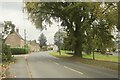
9
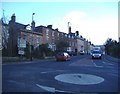
Georgian Dursley
An impressive group of Georgian 'town houses' line the road out of Dursley, towards Tetbury.
Image: © Roger Cornfoot
Taken: 25 Jan 2007
0.17 miles
10
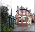
Bus shelter by the Carpenters Arms inn, Dursley
Image: © David Smith
Taken: 29 Dec 2017
0.17 miles