IMAGES TAKEN NEAR TO
Upper Poole Road, DURSLEY, GL11 4LE
Introduction
This page details the photographs taken nearby to Upper Poole Road, GL11 4LE by members of the Geograph project.
The Geograph project started in 2005 with the aim of publishing, organising and preserving representative images for every square kilometre of Great Britain, Ireland and the Isle of Man.

There are currently over 7.5m images from over14,400 individuals and you can help contribute to the project by visiting https://www.geograph.org.uk
Image Map
Images are licensed for reuse under creativecommons.org/licenses/by-sa/2.0
Notes
- Clicking on the map will re-center to the selected point.
- The higher the marker number, the further away the image location is from the centre of the postcode.
Image Listing (159 Images Found)
Images are licensed for reuse under creativecommons.org/licenses/by-sa/2.0
Image
Details
Distance
1
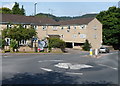
Dursley mini-roundabout
Located at the junction of Lister Street, Uley Road, Bull Pitch and Woodmancote.
Turn left for Tetbury, or right for the town centre, sports centre, Vale Community Hospital, Cam, Stinchcombe and Gloucester.
Image: © Jaggery
Taken: 21 Jul 2012
0.06 miles
2
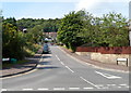
Henlow Drive, Dursley
Viewed from the A4135, here named Bull Pitch.
Image: © Jaggery
Taken: 21 Jul 2012
0.07 miles
3
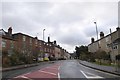
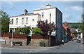
Woodmancote (A4135) in Dursley
The main road south lined with a variety of elegant houses, several of which date from the 18th century and are listed grade II
Image: © David Smith
Taken: 29 Dec 2017
0.10 miles
4
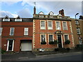
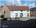
11 Woodmancote, Dursley
A distinguished house of the early to mid eighteenth century https://historicengland.org.uk/listing/the-list/list-entry/1220809
Image: © Jonathan Thacker
Taken: 26 Sep 2021
0.10 miles
5
Henlow House, Dursley
On the corner of Henlow Drive and Bull Pitch. The house was built c1870, enlarged in 1900.
Image: © Jaggery
Taken: 21 Jul 2012
0.10 miles
6
Grade II listed 6 The Broadwell, Dursley
Located in the oldest part of Dursley, this building dates from the early 16th century, though much altered since then. It was the Broadwell Tavern Inn for much of the 17th and 18th centuries. An unusual feature is that a nearby culverted stream opens up into a pond http://www.geograph.org.uk/photo/3053964 in front of the house.
Grade II listed in June 1961.
Image: © Jaggery
Taken: 21 Jul 2012
0.10 miles
7
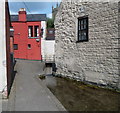
Culverted stream emerges into a small pond, Broadwell, Dursley
Viewed from alongside Grade II listed number 6 The Broadwell. http://www.geograph.org.uk/photo/3053912
In the background is the tower of St James's Church.
Image: © Jaggery
Taken: 21 Jul 2012
0.10 miles
8
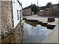
Pond alongside number 6 Broadwell, Dursley
The pond is fed from a stream emerging from a culvert behind the camera. http://www.geograph.org.uk/photo/3053944
Image: © Jaggery
Taken: 21 Jul 2012
0.10 miles
9
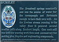
Broadwell plaque, Dursley
The plaque is on a wall near this pond http://www.geograph.org.uk/photo/3053964 which is fed by the spring.
Image: © Jaggery
Taken: 21 Jul 2012
0.10 miles
10
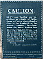
A 2000 replica of an 1827 Caution notice, Water Street, Dursley
The notice is on the wall of a Water Street house adjacent to a water channel, http://www.geograph.org.uk/photo/3054221 which is "the Stream running therefrom" in the notice.
Image: © Jaggery
Taken: 21 Jul 2012
0.10 miles