IMAGES TAKEN NEAR TO
Chipmans Platt, STONEHOUSE, GL10 3SH
Introduction
This page details the photographs taken nearby to Chipmans Platt, GL10 3SH by members of the Geograph project.
The Geograph project started in 2005 with the aim of publishing, organising and preserving representative images for every square kilometre of Great Britain, Ireland and the Isle of Man.

There are currently over 7.5m images from over14,400 individuals and you can help contribute to the project by visiting https://www.geograph.org.uk
Image Map
Images are licensed for reuse under creativecommons.org/licenses/by-sa/2.0
Notes
- Clicking on the map will re-center to the selected point.
- The higher the marker number, the further away the image location is from the centre of the postcode.
Image Listing (65 Images Found)
Images are licensed for reuse under creativecommons.org/licenses/by-sa/2.0
Image
Details
Distance
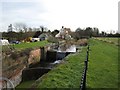
1
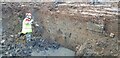
Westfield (John Robinson) Lock
Westfield Lock starts to emerge from over 50 years of infill. Although the top metre of height in the walls is missing, everything else seem to be there, including all of the coping stones. Contrary to popular belief, the lock appears to have been destroyed in part by excavator, rather than being blown up with explosives. Work will be carried out during 2023 by volunteers from the Waterway Recovery Group.
Image: © Jon Pontefract
Taken: 20 Nov 2022
0.06 miles
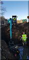
2
Westfield (John Robinson) Lock
The remains of the long lost Westfield Lock begin to emerge from the field. Contrary to popular belief, part of the lock was destroyed by excavators, not explosives. Volunteers from the Waterway Recovery Group will dig out and restore the remains during 2023.
Image: © Jon Pontefract
Taken: 19 Nov 2022
0.06 miles
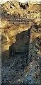
3
Westfield Lock
The dig out underway, with the cill beginning to emerge. Westfield Bridge is in the background. This lock will be known as John Robinson Lock in future, after a generous bequest from the Robinson family. More digging will take place in 2023.
Image: © Jon Pontefract
Taken: 20 Nov 2022
0.07 miles
4
Westfield Bridge & Lock Site
The Stroudwater Canal west of here has been infilled and the line largely obliterated by the construction of the M5 motorway and the Stroudwater junction. Restoration of the canal is likely to involve a diversion to the south using the River Frome.
Image: © David Stowell
Taken: 9 Jan 2008
0.10 miles
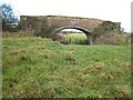
5

Westfield Bridge
An occupation bridge over an infilled section of the Stroudwater Canal. Just in front of the bridge you can see the remains of the Westfield Lock which was blown up during the building of the nearby M5. The keystone reads 1841.
Image: © Symon Parsley
Taken: 1 Apr 2007
0.10 miles
6
Dock Lock
A snappily named lock, presumably due to the adjacent dry dock and the Canal Company's yard on the offside.
Image: © David Stowell
Taken: 9 Jan 2008
0.11 miles
7
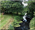
Canal west of Pike Bridge near Eastington
Looking along the Stroudwater Canal from this road bridge. http://www.geograph.org.uk/photo/4052055
Image: © Jaggery
Taken: 29 Jun 2014
0.15 miles
8
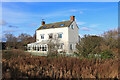
Stroudwater Canal
House by the canal, near Chipmans Platt.
Image: © Wayland Smith
Taken: 5 Dec 2020
0.15 miles
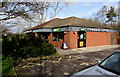
9
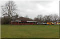
Former Little Chef restaurant to let, Eastington
Viewed in late March 2013. The location is alongside the A419, about 700 metres SE of M5
motorway junction 13. A Travelodge motel and Shell filling station are nearby.
Image: © Jaggery
Taken: 24 Mar 2013
0.16 miles
10
Starbucks Coffee and Subway, Eastington
Set back from the A419 about 700 metres SE of M5 motorway junction 13.
A Travelodge motel and Shell filling station are nearby.
Image: © Jaggery
Taken: 1 Apr 2018
0.16 miles