IMAGES TAKEN NEAR TO
Eastington, STONEHOUSE, GL10 3RT
Introduction
This page details the photographs taken nearby to GL10 3RT by members of the Geograph project.
The Geograph project started in 2005 with the aim of publishing, organising and preserving representative images for every square kilometre of Great Britain, Ireland and the Isle of Man.

There are currently over 7.5m images from over14,400 individuals and you can help contribute to the project by visiting https://www.geograph.org.uk
Image Map
Images are licensed for reuse under creativecommons.org/licenses/by-sa/2.0
Notes
- Clicking on the map will re-center to the selected point.
- The higher the marker number, the further away the image location is from the centre of the postcode.
Image Listing (119 Images Found)
Images are licensed for reuse under creativecommons.org/licenses/by-sa/2.0
Image
Details
Distance
1
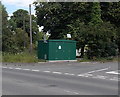
Gas Installation near Eastington
The dark green box is a Wales & West Utilities gas installation, located near Pike Bridge over the Stroudwater Canal.
Image: © Jaggery
Taken: 29 Jun 2014
0.03 miles
2
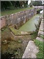
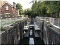
Lock without a Gate
Pikes Lock,
One of the former locks, on the Stroudwater Navigation, Stroud, Gloucestershire
Image: © D M Wilmot
Taken: 7 Oct 2013
0.03 miles
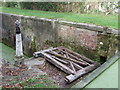
3
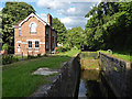
Stroudwater Canal - Pike Lock
The Stroudwater and Thames & Severn Canals are gradually being restored but it is a big job.
Image: © Chris Allen
Taken: 14 Jun 2018
0.03 miles
4
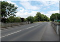
North across Pike Bridge near Eastington
The bridge carries Spring Hill over the Stroudwater Canal near Pike Lock.
The A419 and an approach to M5 motorway junction 13 are ahead.
Image: © Jaggery
Taken: 29 Jun 2014
0.03 miles
5
Pike Lock near Eastington
On the Stroudwater Canal east of Pike Bridge. http://www.geograph.org.uk/photo/4052041
Image: © Jaggery
Taken: 29 Jun 2014
0.04 miles
8
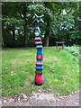
National Cycle Network signpost, Stonehouse
Technically in the parish of Eastington. Alongside the Stroudwater (canal). On an old part of the Bristol Rd, A419. Route 45. For this & milestones in the area see http://umap.openstreetmap.fr/en/map/stonehouse-milestones_519080#14/51.7521/-2.2960
Millennium Time Trail ID: MP692 see http://umap.openstreetmap.fr/en/map/sustrans-mileposts_71773#14/51.7501/-2.3065
Image: © Mr Red
Taken: 7 Sep 2020
0.05 miles
9
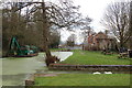
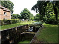
Stroudwater canal terminus at Pike lock near Eastington
View looks westwards towards Pike bridge just beyond the disused lock. The former lock-keeper's cottage is on the right. Currently this is the most westerly point navigable on the restored Stroudwater canal.
Image: © Roger Davies
Taken: 18 Mar 2008
0.05 miles
10
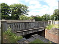
East side of Pike Bridge near Eastington
Pike Bridge carries Spring Hill over the Stroudwater Canal. The year 2005 is inscribed on the bridge.
Image: © Jaggery
Taken: 29 Jun 2014
0.05 miles