1
Grade II listed The Kings Head, King's Stanley
Pub located on the corner of High Street and Broad Street, in the centre of the village. A view http://www.geograph.org.uk/photo/1982786 taken in 2010 shows the pub painted white and with a To Let sign on the wall. The king in the pub sign in 2010 was Henry VIII. The new occupiers have chosen a different colour scheme and a different king for the pub sign. http://www.geograph.org.uk/photo/2702248
Built in 1820, the pub was Grade II listed in February 1987.
A sign on the camera side of Broad Street states BE CAREFUL WHEN YOU CROSS THE ROAD.
Image: © Jaggery
Taken: 20 Nov 2011
0.01 miles
2
Pub sign, The Kings Head, King's Stanley
The Grade II listed pub http://www.geograph.org.uk/photo/2702231 in the centre of King's Stanley has a new look since this view http://www.geograph.org.uk/photo/1982786 taken the previous year. At that time, the pub sign (on the right) depicted Henry VIII. The current one looks like a standard representation of Richard I (the Lionheart).
Image: © Jaggery
Taken: 20 Nov 2011
0.01 miles
3
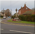
King's Stanley War Memorial
Located in the centre of the village, facing the junction of High Street and Broad Street, and The Kings Head. http://www.geograph.org.uk/photo/2702231
Image: © Jaggery
Taken: 20 Nov 2011
0.01 miles
4
The Green, King's Stanley
The village green is on the west side of Church Street and High Street, opposite the Broad Street junction. The signpost shows (distances in miles) left for Leonard Stanley (¾) and Frocester (2); right for Stonehouse (2). The sign pointing towards the camera shows Village Hall, Middleyard, Selsey (an error - it should be Selsley).
Image: © Jaggery
Taken: 20 Nov 2011
0.01 miles
5
The Red Lion House, King's Stanley
Now in residential use, formerly an inn and brewery, located on The Green in the centre of King's Stanley.
Image: © Jaggery
Taken: 20 Nov 2011
0.01 miles
6
King's Stanley Car Park, Gloucestershire
Free car park on the west side of King's Stanley High Street.
Image: © Jaggery
Taken: 22 Dec 2017
0.02 miles
7
Bathleaze, King's Stanley
Cul-de-sac viewed from the corner of Bath Road.
Image: © Jaggery
Taken: 22 Dec 2017
0.03 miles
8
Bathleaze, King's Stanley
Bathleaze is a cul-de-sac on the north side of Bath Road.
Image: © Jaggery
Taken: 22 Dec 2017
0.03 miles
9
Kings Stanley
Dwelling in Kings Stanley.
Image: © Wayland Smith
Taken: 1 Jun 2014
0.04 miles
10
Wales & West Utilities gas installation, High Street, King's Stanley
Located on the left here. https://www.geograph.org.uk/photo/5734763 A label on the door showing EX warns of a potentially explosive atmosphere - no smoking.
Image: © Jaggery
Taken: 22 Dec 2017
0.05 miles


