IMAGES TAKEN NEAR TO
Claypits, STONEHOUSE, GL10 3AJ
Introduction
This page details the photographs taken nearby to Claypits, GL10 3AJ by members of the Geograph project.
The Geograph project started in 2005 with the aim of publishing, organising and preserving representative images for every square kilometre of Great Britain, Ireland and the Isle of Man.

There are currently over 7.5m images from over14,400 individuals and you can help contribute to the project by visiting https://www.geograph.org.uk
Image Map
Images are licensed for reuse under creativecommons.org/licenses/by-sa/2.0
Notes
- Clicking on the map will re-center to the selected point.
- The higher the marker number, the further away the image location is from the centre of the postcode.
Image Listing (29 Images Found)
Images are licensed for reuse under creativecommons.org/licenses/by-sa/2.0
Image
Details
Distance
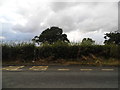
1
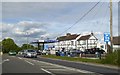
Hilltop Garage
Hilltop Garage at Claypits on the A38.
Image: © Philip Halling
Taken: 11 Feb 2012
0.15 miles
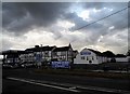
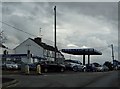
4
Hilltop Garage at Claypits
There is a spot height of 32 metres nearby, making this the top of a very low hill
Image: © David Smith
Taken: 15 Jun 2018
0.16 miles
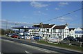
5

Hilltop Garage, Claypit, Gloucestershire
Image: © nick macneill
Taken: 14 Oct 2012
0.16 miles
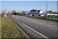
7
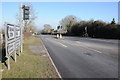
Road junction at Claypits
Road junction at Claypits on the A38.
Image: © Philip Halling
Taken: 11 Feb 2012
0.16 miles
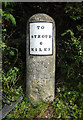
8
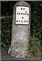
Old Milestone by the A38, Claypits, Eastington parish
Metal plate attached to stone post by the A38, in parish of EASTINGTON (STROUD District), Claypits; opposite garage, East corner of junction, by traffic lights. Stroud iron plate, erected by the Cainscross (Division) turnpike trust in the 19th century.
Inscription reads:-
TO
STROUD
6
MILES
Grade II listed.
List Entry Number: 1090554 https://historicengland.org.uk/listing/the-list/list-entry/1090554
Milestone Society National ID: GL_SDGL06.
Image: © C Minto
Taken: 22 Oct 2007
0.16 miles
9
Milestone A38, Eastington turn
Metal plate attached to stone post by the A38, in parish of EASTINGTON (STROUD District), Claypits; opp. garage, NE corner jcn , by traffic lights, on North side of road. Stroud iron plate erected by the Cainscross (Division) turnpike trust in the 19th century. Alternative image - https://www.geograph.org.uk/photo/6048599 More milestones in the area see http://umap.openstreetmap.fr/en/map/stonehouse-milestones_519080#14/51.7521/-2.2960
Inscription reads:- : TO / STROUD / 6 / MILES
Listed.
Milestone Society National ID: GL_SDGL06
Image: © Mr Red
Taken: 4 Sep 2020
0.17 miles