IMAGES TAKEN NEAR TO
Browns Lane, STONEHOUSE, GL10 2JN
Introduction
This page details the photographs taken nearby to Browns Lane, GL10 2JN by members of the Geograph project.
The Geograph project started in 2005 with the aim of publishing, organising and preserving representative images for every square kilometre of Great Britain, Ireland and the Isle of Man.

There are currently over 7.5m images from over14,400 individuals and you can help contribute to the project by visiting https://www.geograph.org.uk
Image Map
Images are licensed for reuse under creativecommons.org/licenses/by-sa/2.0
Notes
- Clicking on the map will re-center to the selected point.
- The higher the marker number, the further away the image location is from the centre of the postcode.
Image Listing (155 Images Found)
Images are licensed for reuse under creativecommons.org/licenses/by-sa/2.0
Image
Details
Distance
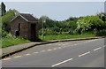
1

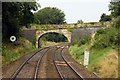
Brown's Lane, Stonehouse
Brown's Lane descends from a railway bridge, http://www.geograph.org.uk/photo/1629988 towards Bath Road.
Image: © Jaggery
Taken: 14 Jun 2015
0.04 miles
3
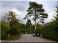
Brown's lane, Ryeford
A small quiet backwater of residential properties that back onto the Stroud to Stonehouse railway line just off the A4088. The lane crosses the line by a small bridge a few yards further on.(see Image)
Image: © Nigel Mykura
Taken: 7 Oct 2011
0.05 miles
4
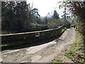
Brown's Lane bridge
Known locally as Schoolboys' Bridge, due to its proximity to the college. Curiously, the railways refer to it as Shepherds Overbridge.
Image: © Neil Owen
Taken: 7 Feb 2023
0.05 miles
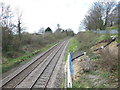
5

Railway from Stonehouse towards Stroud
From Brown's Lane bridge http://www.geograph.org.uk/photo/1629988
Image: © Jaggery
Taken: 14 Jun 2015
0.07 miles
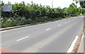
6
Horsetrough Roundabout directions sign, Ebley Road, Stonehouse
Partly hidden by vegetation in May 2017, the sign faces westbound traffic
on the B4008 Ebley Road 200 metres from the Horsetrough Roundabout at the A419 junction.
Image: © Jaggery
Taken: 7 May 2017
0.12 miles
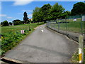
7
Ebley Road bus stop and shelter, Stonehouse
This stop is for buses from Stroud to Gloucester via Stonehouse town centre.
Image: © Jaggery
Taken: 7 May 2017
0.12 miles
8
Entrance drive to Wycliffe Nursery, Stonehouse
A 5mph speed limit is in force along the entrance drive on the north side of the B4008 Ebley Road.
Wycliffe Nursery School is located within the grounds of Wycliffe Preparatory School.
Image: © Jaggery
Taken: 7 May 2017
0.12 miles
9
The railway line at Ryeford, west bound
The Cotswold Way, day three 2:12pm
Image: © Ian S
Taken: 19 Apr 2013
0.13 miles
10
Directions sign on the approach to Horsetrough Roundabout, Stonehouse
Facing westbound traffic on the B4008 Ebley Road.
Image: © Jaggery
Taken: 7 May 2017
0.13 miles