IMAGES TAKEN NEAR TO
Churchill Square, HELENSBURGH, G84 9HN
Introduction
This page details the photographs taken nearby to Churchill Square, G84 9HN by members of the Geograph project.
The Geograph project started in 2005 with the aim of publishing, organising and preserving representative images for every square kilometre of Great Britain, Ireland and the Isle of Man.

There are currently over 7.5m images from over14,400 individuals and you can help contribute to the project by visiting https://www.geograph.org.uk
Image Map
Images are licensed for reuse under creativecommons.org/licenses/by-sa/2.0
Notes
- Clicking on the map will re-center to the selected point.
- The higher the marker number, the further away the image location is from the centre of the postcode.
Image Listing (24 Images Found)
Images are licensed for reuse under creativecommons.org/licenses/by-sa/2.0
Image
Details
Distance
1
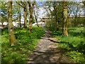
Woodland path in Churchill Estate
The properties in the background are on a street called Hardy Hill; they were being refurbished when this picture was taken.
See also Image
Image: © Lairich Rig
Taken: 22 May 2013
0.07 miles
2
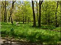
Woodland paths in Churchill Estate
This area of woodland lies within the housing estate (compare Image); that is why lamp posts can be seen beside the paths.
Image: © Lairich Rig
Taken: 22 May 2013
0.07 miles
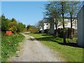
3
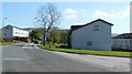
Churchill Estate, Helensburgh
This outlying area of the town consists of housing that was built for Ministry of Defence employees (see Image). From here on, the road is called Winston Road; behind the photographer's position, it is called Golfhill Drive.
The picture was taken from the junction with Fisher Place (foreground right).
Image: © Lairich Rig
Taken: 2 May 2011
0.10 miles
4
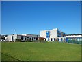
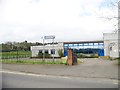
John Logie Baird Primary School, Helensburgh
Image: © Stephen Sweeney
Taken: 19 Feb 2013
0.14 miles
5
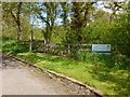
Entrance to Garrawy Glen
The entrance (also shown in an earlier picture – Image) is beside Winston Road (that road is shown in Image).
For a view back from the other side of the gate, see Image
Image: © Lairich Rig
Taken: 22 May 2013
0.15 miles
6
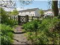
Leaving Garrawy Glen
For views of the gate from the other side, see Image and Image
For the road in the background, see Image
Image: © Lairich Rig
Taken: 22 May 2013
0.15 miles
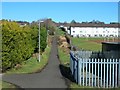
7
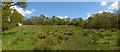
Grassy space near Helensburgh
This area is between the houses of Churchill Estate (background left) and the wooded Garrawy Glen, which is behind a metal fence on the right.
Image: © Lairich Rig
Taken: 22 May 2013
0.16 miles
9
Small path by school in east Helensburgh
Image: © Stephen Sweeney
Taken: 19 Feb 2013
0.17 miles
10
Old Luss Road
This is the southern end of a route called Old Luss Road. At this end, the path begins at Image
See also Image, which was taken from the gate that is visible ahead.
The same gate is shown, from the other side, in a later picture: Image
Image: © Lairich Rig
Taken: 2 May 2011
0.18 miles