IMAGES TAKEN NEAR TO
Lever Road, HELENSBURGH, G84 9DT
Introduction
This page details the photographs taken nearby to Lever Road, G84 9DT by members of the Geograph project.
The Geograph project started in 2005 with the aim of publishing, organising and preserving representative images for every square kilometre of Great Britain, Ireland and the Isle of Man.

There are currently over 7.5m images from over14,400 individuals and you can help contribute to the project by visiting https://www.geograph.org.uk
Image Map
Images are licensed for reuse under creativecommons.org/licenses/by-sa/2.0
Notes
- Clicking on the map will re-center to the selected point.
- The higher the marker number, the further away the image location is from the centre of the postcode.
Image Listing (6 Images Found)
Images are licensed for reuse under creativecommons.org/licenses/by-sa/2.0
Image
Details
Distance
1
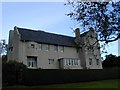
Hill House Architect: Charles Rennie Mackintosh
Hill House, the largest and finest of Mackintosh's domestic buildings, occupies a hillside that looks out over the Clyde estuary.
Image: © Michael Parry
Taken: 13 Oct 2000
0.19 miles
2
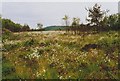
Blackhill Mire
This site just outside Helensburgh had the largest known colony of the Green Hairstreak butterfly (Callophrys rubi) in the Greater Glasgow area in 1992.
The white seed heads are of Common Cotton-grass (Eriophorum angustifolium).
Image: © Richard Sutcliffe
Taken: 5 Jun 1992
0.21 miles
3
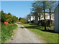
Old Luss Road
This is the southern end of a route called Old Luss Road. At this end, the path begins at Image
See also Image, which was taken from the gate that is visible ahead.
The same gate is shown, from the other side, in a later picture: Image
Image: © Lairich Rig
Taken: 2 May 2011
0.24 miles
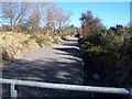
4
Old Luss Road
In this view downhill (south), the Churchill Estate is just beyond the gate that can be seen ahead. The same gate is shown, from the other side, in Image
Another contributor's earlier picture shows the same section of path as appears in the present picture, but the view is in the opposite direction (north, and uphill), and the path was then much less overgrown: Image
Image: © Lairich Rig
Taken: 17 Aug 2015
0.24 miles
5
Helensburgh, Old Luss Road
A public right of way if you can climb over the padlocked gate.
Image: © william craig
Taken: 21 Mar 2006
0.24 miles
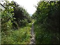
6
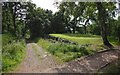
Old Luss Road
The path and right of way that is called Old Luss Road is shown on the left, receding into the distance. The path crossing it in the foreground is associated with a golf course which Old Luss Road traverses. This part of the path is at the lower end of the course, and is near the Churchill Estate.
Image: © Lairich Rig
Taken: 17 Aug 2015
0.24 miles