IMAGES TAKEN NEAR TO
Rhu Road Lower, HELENSBURGH, G84 8SF
Introduction
This page details the photographs taken nearby to Rhu Road Lower, G84 8SF by members of the Geograph project.
The Geograph project started in 2005 with the aim of publishing, organising and preserving representative images for every square kilometre of Great Britain, Ireland and the Isle of Man.

There are currently over 7.5m images from over14,400 individuals and you can help contribute to the project by visiting https://www.geograph.org.uk
Image Map
Images are licensed for reuse under creativecommons.org/licenses/by-sa/2.0
Notes
- Clicking on the map will re-center to the selected point.
- The higher the marker number, the further away the image location is from the centre of the postcode.
Image Listing (74 Images Found)
Images are licensed for reuse under creativecommons.org/licenses/by-sa/2.0
Image
Details
Distance
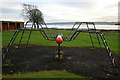
1
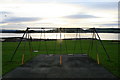
Swings in Kidston Park
Apparently this park was "chiefly the gift of" William Kidston Esq and was opened in 1877.
Image: © David Lally
Taken: 12 Nov 2008
0.01 miles
2
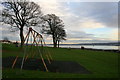
Kidson Park
On the northern edge of Helensburgh
Image: © David Lally
Taken: 12 Nov 2008
0.01 miles
3
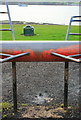
Climbing Frame and Mine Sweeper.
Kidston Park.
Image: © David Lally
Taken: 12 Nov 2008
0.01 miles
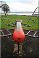
5
Climbing Frame, Kidston Park
With a fine view toward Greenock.
Image: © David Lally
Taken: 12 Nov 2008
0.01 miles
6
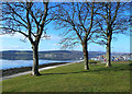
Cairndhu Point
At the western end of Helensburgh sea front.
Image: © Mary and Angus Hogg
Taken: 1 Mar 2013
0.02 miles
7
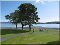
Kidston Park
Cairndhu Point at the mouth of the Gare Loch.
Image: © Richard Webb
Taken: 31 May 2016
0.02 miles
8
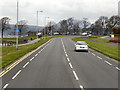
Helensburgh, Rhu Road Lower
The coastal road, near Kidston Park.
Image: © David Dixon
Taken: 19 Apr 2012
0.02 miles
9
Plaque on former bandstand in Kidston Park
See Image, Image and Image for views of the former bandstand in context.
For more on the Kidstons of Ferniegair, and on the William Kidston who is mentioned in this inscription, see http://www.glasgownecropolis.org/profiles/the-kidston-family/ (at Friends of Glasgow Necropolis); the inscription shown in the present photograph is the one that is mentioned in that article's discussion of Kidston Park.
Image: © Lairich Rig
Taken: 2 Apr 2013
0.02 miles
10
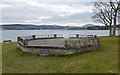
Kidston Park
The structure shown here was, before its whole upper part was removed, a bandstand. For later views in sunlight, see Image and Image
The park is on Image, which was once popularly known as Neddy's Point, after the Duke of Argyll's fisherman (see the footnote on page 111 of W C Maughan's 1897 "Annals of Garelochside"; page 12 of Donald MacLeod's 1883 book "Garelochside and Helensburgh" gives further anecdotal details about Neddy).
For the plaque that can be seen on the near side of the former bandstand, and for links to information about William Kidston of Ferniegair, after whom the park is named, see Image
The prominent background hill above the right-hand end of the former bandstand is Creachan Mòr (Image).
Image: © Lairich Rig
Taken: 2 Apr 2013
0.02 miles