IMAGES TAKEN NEAR TO
Fraser Avenue, HELENSBURGH, G84 8QP
Introduction
This page details the photographs taken nearby to Fraser Avenue, G84 8QP by members of the Geograph project.
The Geograph project started in 2005 with the aim of publishing, organising and preserving representative images for every square kilometre of Great Britain, Ireland and the Isle of Man.

There are currently over 7.5m images from over14,400 individuals and you can help contribute to the project by visiting https://www.geograph.org.uk
Image Map
Images are licensed for reuse under creativecommons.org/licenses/by-sa/2.0
Notes
- Clicking on the map will re-center to the selected point.
- The higher the marker number, the further away the image location is from the centre of the postcode.
Image Listing (69 Images Found)
Images are licensed for reuse under creativecommons.org/licenses/by-sa/2.0
Image
Details
Distance
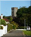
1
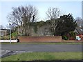
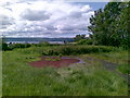
Retaining wall below Ardencaple Tower
The tower itself is not well seen from here, but it is shown in Image, and summarised in the end-note. Click on the end-note title for related pictures of it.
In the present picture, the tower itself is obscured by the tree on the left, but the main point of the picture is not to show the tower, but rather its setting. Housing built here after 1957 has changed the area greatly, but the retaining wall still makes it clear that the tower occupies a position at the top of a precipice.
The geology of the area and its influence on the choice of this location for the castle were described very well by George Campbell, the 8th Duke of Argyll, in his autobiography. The relevant passages are as follows, where I have added a couple of links to illustrate the geological features that are mentioned:
"One special feature of the whole estuary of the Clyde was conspicuous at Ardencaple. That feature is an 'old coast line' which marks a higher level at which the sea used to stand, and must have stood for ages, from about 30 to 60 feet above the present level of the sea. This old coast-line is marked by a steep bank (Image), sometimes rocky, with caves (Image) eaten out by the waves, or with projecting ledges undercut by passing sheets of ice.
The distance at which this bank stands back from the present line of the shore depends, of course, on the contours of the land. When those contours are steep, the distance is often very small; where they are gentle and gradual, there may be large and nearly level fields separating the old from the present coast-line. In the Middle Ages all sudden declivities were more or less valuable for the purposes of defence, and fortified houses were often built upon this line of steeps.
...
The old castle of Ardencaple had been built on the crest of the old coast-line, at a point where it was very steep and formed a projecting curve, so that the walls could have the benefit of a natural defence on two sides."
["Autobiography and Memoirs of George Douglas, Eighth Duke of Argyll, K.G., K.T. (1823–1900)", (2 vols; London; John Murray, 1906).]
Image: © Lairich Rig
Taken: 2 Feb 2015
0.05 miles
2
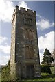
Ardencaple Tower, Helensburgh
All that is left of Ardencaple Castle, which was demolished in 1957-58. The original castle is said to date from the 13th century, but most was built in 1583 by the 11th laird. The Castle was the traditional home of the Clan MacAulay from the 13th to 18th century. See also Image
Image: © Becky Williamson
Taken: 7 Apr 2011
0.06 miles
3
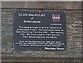
Plaque on Ardencaple Tower, Helensburgh
The original castle is said to date from the 13th century, but most was built in 1583 by the 11th laird. The NW tower is all that is left of the Castle today. See also Image]
Image: © Becky Williamson
Taken: 7 Apr 2011
0.06 miles
4
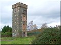
Ardencaple Tower
For further details, click on the end-note title. For other contributors' pictures, see Image and Image
For context, and for a discussion of how the geology of the area influenced the choice of this site as the location of a castle, see Image See also Image for further context.
Apart from this one tower, what remained of Ardencaple Castle was demolished c.1957 to make way for housing (this being Helensburgh, the housing was intended mainly for naval personnel). The tower is located near the junction of Frazer Avenue and West King Street.
Image: © Lairich Rig
Taken: 26 Oct 2011
0.06 miles
5
Ardencaple Castle
The tower is all that now remains of the Category B listed https://portal.historicenvironment.scot/designation/LB34703 Ardencaple Castle. Originally the seat of the Clan MacAulay the castle fell into ruin and was sold off in the 1760s. It was repaired and altered in the 1780s and further alterations were made in 1877. The rest of the castle was demolished in 1957.
Image: © Richard Sutcliffe
Taken: 5 Sep 2023
0.07 miles
6
Ardencaple Tower: detail
For context, see Image, where this feature can be seen above blocked-up windows and a plaque that is shown in Image
Although the castle was long associated with Clan MacAulay, the coat-of-arms shown here refers, instead, to Clan Campbell, members of which owned Ardencaple Castle for parts of the eighteenth and nineteenth centuries; the lymphads/galleys and Latin motto ("ne obliviscaris") refer to that clan. The Y-shaped elements are shakeforks.
I have found no reference that explains in detail the heraldry shown here. However, two coats-of-arms are incorporated, side by side (this is called "impalement"). The (viewer's) left-hand side contains the coat-of-arms of the Dukes of Argyll; the tower was built by Lord John Campbell, who would become the 7th Duke of Argyll.
I consider it likely that the right-hand side contains the arms of his third wife, Anne Cunninghame, whom he married in 1831, and who was probably his wife at the time when this tower was built; the shakefork is certainly a feature of the Cunninghame arms. As the end-note points out, the tower was built following a fire that damaged the north-western parts of the castle; that fire is said to have occurred in about 1830.
Click on the end-note title for more pictures of the tower.
Image: © Lairich Rig
Taken: 17 Nov 2014
0.07 miles
7
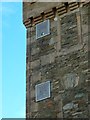
Ardencaple Tower: navigation lights
There are two fixed green lights near the top of one side of Ardencaple Tower, which is also, for the purposes of navigation, known as Ardencaple Castle Light. The tower itself is the sole standing remnant of Ardencaple Castle.
For context, see Image, a view of the whole tower; the lights can be seen in that picture. For related pictures, click on the end-note title.
Image: © Lairich Rig
Taken: 17 Nov 2014
0.07 miles
8
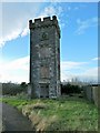
Ardencaple Tower
This is the sole standing remnant of Ardencaple Castle. For other pictures of the tower, click on the end-note title. See also Image and Image for other contributors' pictures.
Image: © Lairich Rig
Taken: 17 Nov 2014
0.07 miles
10
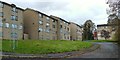
Jutland Court
The photograph was taken from West King Street. At the time of writing, these flats, which were built in the 1960s, are mostly (but not entirely) unoccupied, and they are set to be either refurbished or demolished.
Image: © Lairich Rig
Taken: 26 Oct 2011
0.09 miles