Ardencaple Tower: detail
Introduction
The photograph on this page of Ardencaple Tower: detail by Lairich Rig as part of the Geograph project.
The Geograph project started in 2005 with the aim of publishing, organising and preserving representative images for every square kilometre of Great Britain, Ireland and the Isle of Man.

There are currently over 7.5m images from over 14,400 individuals and you can help contribute to the project by visiting https://www.geograph.org.uk
Ardencaple Tower: detail
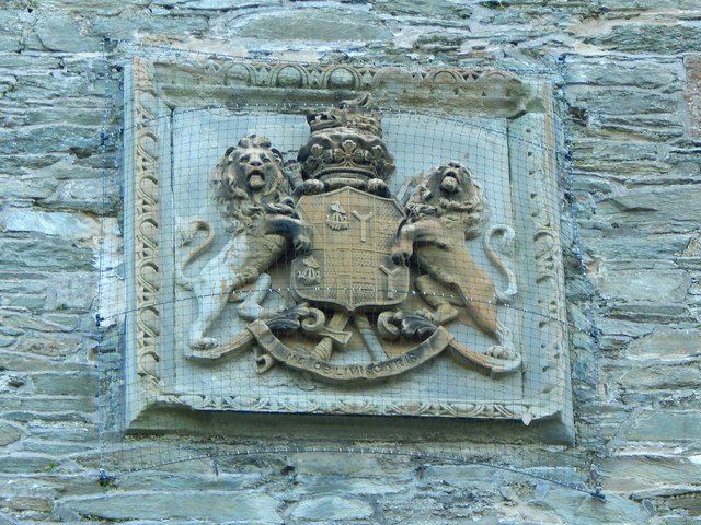
Image: © Lairich Rig Taken: 17 Nov 2014
For context, see Image, where this feature can be seen above blocked-up windows and a plaque that is shown in Image Although the castle was long associated with Clan MacAulay, the coat-of-arms shown here refers, instead, to Clan Campbell, members of which owned Ardencaple Castle for parts of the eighteenth and nineteenth centuries; the lymphads/galleys and Latin motto ("ne obliviscaris") refer to that clan. The Y-shaped elements are shakeforks. I have found no reference that explains in detail the heraldry shown here. However, two coats-of-arms are incorporated, side by side (this is called "impalement"). The (viewer's) left-hand side contains the coat-of-arms of the Dukes of Argyll; the tower was built by Lord John Campbell, who would become the 7th Duke of Argyll. I consider it likely that the right-hand side contains the arms of his third wife, Anne Cunninghame, whom he married in 1831, and who was probably his wife at the time when this tower was built; the shakefork is certainly a feature of the Cunninghame arms. As the end-note points out, the tower was built following a fire that damaged the north-western parts of the castle; that fire is said to have occurred in about 1830. Click on the end-note title for more pictures of the tower.
Images are licensed for reuse under creativecommons.org/licenses/by-sa/2.0
Image Location
Latitude
56.008974
Longitude
-4.75684