IMAGES TAKEN NEAR TO
Shandon, HELENSBURGH, G84 8NW
Introduction
This page details the photographs taken nearby to G84 8NW by members of the Geograph project.
The Geograph project started in 2005 with the aim of publishing, organising and preserving representative images for every square kilometre of Great Britain, Ireland and the Isle of Man.

There are currently over 7.5m images from over14,400 individuals and you can help contribute to the project by visiting https://www.geograph.org.uk
Image Map
Images are licensed for reuse under creativecommons.org/licenses/by-sa/2.0
Notes
- Clicking on the map will re-center to the selected point.
- The higher the marker number, the further away the image location is from the centre of the postcode.
Image Listing (12 Images Found)
Images are licensed for reuse under creativecommons.org/licenses/by-sa/2.0
Image
Details
Distance
1
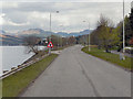
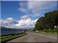
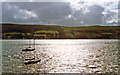
Gare Loch
Looking along the A814,coastal road. at Gare Loch.
Image: © David Dixon
Taken: 19 Apr 2012
0.10 miles
2
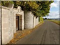
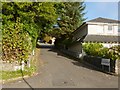
Entrance beside Shore Road, Shandon
This entrance was probably associated with the Ardgare Estate.
Compare the similar detail above the doorway of an unrelated entrance about a mile to the NNW: Image
Image: © Lairich Rig
Taken: 15 Oct 2012
0.10 miles
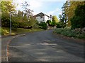
4
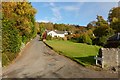
Stuckenduff Farm Road
Stuckenduff Farm (which is not the building visible ahead) is about 700 metres from here, as measured along the road.
Image: © Lairich Rig
Taken: 15 Oct 2012
0.12 miles
6
Queens Point and the former Croy Lodge
The road branching off to the right is called Image (the sign says "Queens Point leading to Kings Point"). The building at the corner was a lodge associated with Croy. Croy House itself dates from 1834, and is at Image
The cycle path is part of Regional Route 42.
Image: © Lairich Rig
Taken: 15 Oct 2012
0.14 miles
7
Queens Point
The road is called Queens Point. The picture was taken from near a former lodge that stands beside the beginning of the road. The lodge and the start of the road are shown in Image
Image: © Lairich Rig
Taken: 15 Oct 2012
0.16 miles
8
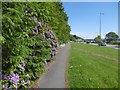
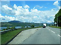
A814, Croy
The road, busy at the time with a shift change up at Faslane, is accompanied by a wide verge/park. This is an area of large houses and ribbon development.
Image: © Richard Webb
Taken: 31 May 2016
0.17 miles
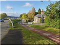
9
Gareloch Brae, Shandon
The sign says "leading to The Birches".
Image: © Lairich Rig
Taken: 15 Oct 2012
0.20 miles
10
Evening scene at Shandon across Gare Loch
View west from A814 road across to Roseneath shore.
Image: © Ben Brooksbank
Taken: 22 Jun 1994
0.21 miles