IMAGES TAKEN NEAR TO
Rhu, HELENSBURGH, G84 8NE
Introduction
This page details the photographs taken nearby to G84 8NE by members of the Geograph project.
The Geograph project started in 2005 with the aim of publishing, organising and preserving representative images for every square kilometre of Great Britain, Ireland and the Isle of Man.

There are currently over 7.5m images from over14,400 individuals and you can help contribute to the project by visiting https://www.geograph.org.uk
Image Map
Images are licensed for reuse under creativecommons.org/licenses/by-sa/2.0
Notes
- Clicking on the map will re-center to the selected point.
- The higher the marker number, the further away the image location is from the centre of the postcode.
Image Listing (45 Images Found)
Images are licensed for reuse under creativecommons.org/licenses/by-sa/2.0
Image
Details
Distance
1
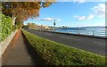
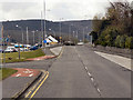
Gareloch Road, Rhu
In this wide-angle view, the large building visible ahead is marked on the 1:25000 map, where it is labelled "depot". It is the Clyde Off-Site Centre / Media Reception building, which is also shown in Image
Image: © Lairich Rig
Taken: 1 Nov 2016
0.04 miles
2
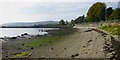
The shore near Rhu Marina
Image: © Lairich Rig
Taken: 28 Sep 2013
0.06 miles
3
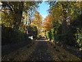
The foot of Artarman Road, Rhu
The view is from the junction with the shore road.
Image: © Lairich Rig
Taken: 1 Nov 2016
0.06 miles
4
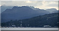
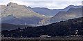
Rhu marina and the Arrochar Alps
A dark and moody Arrochar Alps, with Rhu Marina in the foreground. Viewed from the riverside footpath near Tesco, Port Glasgow.
Image: © Thomas Nugent
Taken: 30 Aug 2015
0.08 miles
5
Rhu from Port Glasgow
The big shed is at HMNB Clyde Off-site Centre, which is a designated incident control centre with media facilities to be used in the event of a radiation emergency at the base.
Image: © Thomas Nugent
Taken: 14 Sep 2017
0.08 miles
6

Rhu from Port Glasgow
Rhu parish Church Image can be seen near the centre of the photo which was taken from the riverside path opposite Tesco.
Image: © Thomas Nugent
Taken: 19 Jun 2017
0.08 miles
7
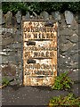
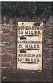
Old milestone at Rhu
The stone is set in a wall next to a bus stop on Image (see that photograph for context). The milestone is an old one; it is shown, at or near its present position, on the first-edition OS map (surveyed in 1860).
"Dunbarton 10 miles / Garelochhead 5½ miles / Arrochar 15½ miles"
The spelling "Dunbarton" is one that was favoured by the Trustees of Turnpike Roads (for reasons that are explained in Image). Compare Image
Image: © Lairich Rig
Taken: 12 Sep 2012
0.09 miles
9
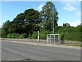
Gareloch Road
The bus stop faces a road leading to Rhu Marina, and is just out of shot to the right in another photo: Image In the present photograph, the object that is set in the wall, just left of centre, is an old milestone; for a closer look, see Image
Image: © Lairich Rig
Taken: 12 Sep 2012
0.09 miles
10
Old Milepost by the A814, Gareloch Road, Rhu, Row parish
Glasgow flat by the A814, in parish of Row (Argyll & Bute District), Rhu, Gareloch Road, on front of wall, West of bus shelter, North side of road.
Inscription reads:-
{hand->}
DUNBARTON
10 MILES
{line}
{<-hand}
GARELOCHHEAD
5½ MILES
{line}
{<-hand}
ARROCHAR
15½ MILES
{line}
Surveyed
Milestone Society National ID: AB_DMAC10
Image: © Milestone Society
Taken: Unknown
0.09 miles