IMAGES TAKEN NEAR TO
Maitland Street, HELENSBURGH, G84 7PB
Introduction
This page details the photographs taken nearby to Maitland Street, G84 7PB by members of the Geograph project.
The Geograph project started in 2005 with the aim of publishing, organising and preserving representative images for every square kilometre of Great Britain, Ireland and the Isle of Man.

There are currently over 7.5m images from over14,400 individuals and you can help contribute to the project by visiting https://www.geograph.org.uk
Image Map
Images are licensed for reuse under creativecommons.org/licenses/by-sa/2.0
Notes
- Clicking on the map will re-center to the selected point.
- The higher the marker number, the further away the image location is from the centre of the postcode.
Image Listing (415 Images Found)
Images are licensed for reuse under creativecommons.org/licenses/by-sa/2.0
Image
Details
Distance
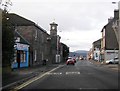
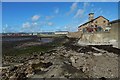
2
East Clyde Street
'Twist Cafe' and 'Partners' occupy the nearest properties. In the distance is the Category C listed Bell Tower of the former parish church, Helensburgh.
Image: © Richard Sutcliffe
Taken: 1 Mar 2019
0.01 miles
3
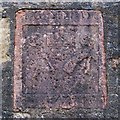
Old carved stone, Maitland Street
A friend noticed this stone, and drew my attention to it, showing me a photograph of it. We wished to know more about it, and I was keen to take a look for myself. The stone is built into a wall at the shore end of Maitland Street.
The two lower symbols are compasses and an adze, indicating a profession that involves working with wood. The leftmost symbol in the top row is a circle with a smaller circle placed off-centre within it, resembling the end of a barrel (the adjacent symbols may represent a barrel as seen from the side and from the other end), suggesting the cooper's art. At the bottom of the stone is a date, 1778. At the top are some pairs of letters, presumably initials.
Taken together, the profession indicated by the symbols, the year 1778 that is shown on the stone, and its location in Maitland Street, led me to an account that explains its presence here. In one section of his book "Annals of Garelochside" (1897), William Charles Maughan draws on the memories of a certain Mr McAulay, fisherman, in describing the early buildings of Helensburgh:
"The oldest houses in the town he considers to be the red tiled ones at the foot of Maitland Street, which used to be occupied by John Gray, while a cooperage was situated on the shore, nearly opposite; but in one of the great storms, more than sixty years ago, this building was entirely washed away. There was a carved stone over the door, with the cooper's coat of arms, consisting of the letters P.G.M.D.G., a pair of compasses, and some implements, with the date 1778, which is now to be seen built into the wall of the house at the foot of the street next the shore."
[As the photograph shows, the letter M is doubled (thus: "PG MM DG"), but the book's description of the stone is otherwise correct.]
Image: © Lairich Rig
Taken: 26 Oct 2011
0.02 miles
4
Dry Cleaners and Laundrette
On East Clyde Street. The business offers an extensive service. Advertised in the window it says:
SAME DAY SERVICE - ANIMAL LAUNDRY HORSE RUGS PET BEDS - ALTERATIONS AND REPAIRS - SPORTS KITS DUVETS CURTAINS LOOSE COVERS - DRY CLEANING IRONING
Next door is Yummy House, a Chinese take-away.
Image: © Richard Sutcliffe
Taken: 4 Mar 2024
0.02 miles
5
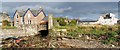
The shore at Helensburgh
The view is from near the shore end of Maitland Street. Helensburgh Pier with its car park is in the left background; on the right is the spire of what was once the parish church, and which was later, but is no longer, the Tourist Information Centre. On its near side is courtyard housing at Tower Place.
Maitland Street itself was a very early part of the town of Helensburgh: see Image The cooperage mentioned there stood only a short distance from the point where this picture was taken.
Image: © Lairich Rig
Taken: 22 Sep 2016
0.03 miles
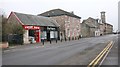
6
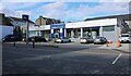
Wright's Home Hardware
On East Clyde Street. Including Wright's garden centre and furniture showroom.
Image: © Richard Sutcliffe
Taken: 4 Mar 2024
0.04 miles
7
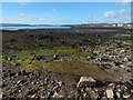
Old Red Sandstone on shore at Helensburgh
The viewpoint is only a few metres to the east of that for Image; a grey feature in the left foreground of that picture can be seen ahead, on the right, in the present view.
As BGS geological maps reveal, Rosneath Conglomerate (formerly called Upper Old Red Sandstone) is present on the shore from here to about Image In fact, the spot from which the present picture was taken is the south-eastern extremity of this part of the formation, as marked on the geological map.
Old Red Sandstone is also prominent elsewhere on the Clyde shore: around and to the north-west of Ardmore Point (see Image and Image, respectively), and near Image in Cardross.
Image: © Lairich Rig
Taken: 22 Sep 2016
0.04 miles
8
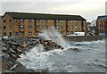
Flats beside the shore
On a very windy day, waves break over the sea wall and into the car park of the flats at Tower Place, built on the site of the former parish church.
Image: © Richard Sutcliffe
Taken: 11 Nov 2022
0.04 miles
9
The Milligs Burn
This picture shows the burn flowing, by means of the aperture left of centre, onto the beach at Helensburgh (for a view of the same area from further away, see Image). The burn has its origins at about Image, a short distance to the north-west of the reservoirs (Image and Image) that are to the north of the town; on the way here, it flows through Image, as shown in Image
For a view in the opposite direction from about the same point as the present picture, see Image, showing the burn flowing towards the Clyde.
The name Millig, encountered in various spellings, has been associated with the area for a very long time. In the item Image, I record its use from as early as 1225; see that item for more information.
[Regarding the founding of Helensburgh (in 1777) on the lands of Millig, the first volume of "The Chiefs of Colquhoun and their Country" (William Fraser, 1869) explains that "the barony of Malligs" had previously been owned by Sir John Shaw of Greenock; when he died in 1752, those lands went first to his widow, and then to his only child, Margaret, and her husband, Lord Cathcart. These sold it to Sir James Colquhoun (1714-1786), 1st Baronet Colquhoun of Luss; the last payment was made in June 1756. James wished to create a burgh of barony on the lower parts of the lands; he would eventually name it after his wife, Lady Helen.]
Image: © Lairich Rig
Taken: 26 Oct 2011
0.05 miles
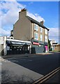
10
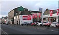
Arnold Clark car dealership
On East Clyde Street, Helensburgh.
Image: © Richard Sutcliffe
Taken: 24 Dec 2019
0.05 miles