Old carved stone, Maitland Street
Introduction
The photograph on this page of Old carved stone, Maitland Street by Lairich Rig as part of the Geograph project.
The Geograph project started in 2005 with the aim of publishing, organising and preserving representative images for every square kilometre of Great Britain, Ireland and the Isle of Man.

There are currently over 7.5m images from over 14,400 individuals and you can help contribute to the project by visiting https://www.geograph.org.uk
Old carved stone, Maitland Street
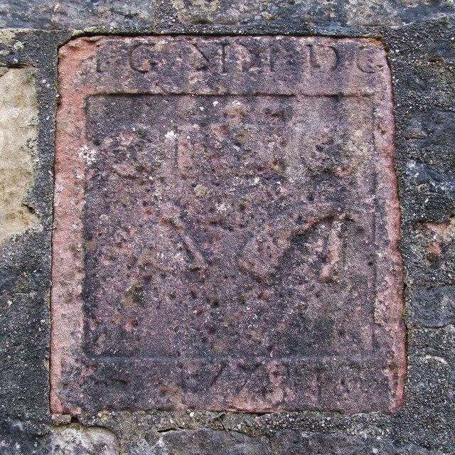
Image: © Lairich Rig Taken: 26 Oct 2011
A friend noticed this stone, and drew my attention to it, showing me a photograph of it. We wished to know more about it, and I was keen to take a look for myself. The stone is built into a wall at the shore end of Maitland Street. The two lower symbols are compasses and an adze, indicating a profession that involves working with wood. The leftmost symbol in the top row is a circle with a smaller circle placed off-centre within it, resembling the end of a barrel (the adjacent symbols may represent a barrel as seen from the side and from the other end), suggesting the cooper's art. At the bottom of the stone is a date, 1778. At the top are some pairs of letters, presumably initials. Taken together, the profession indicated by the symbols, the year 1778 that is shown on the stone, and its location in Maitland Street, led me to an account that explains its presence here. In one section of his book "Annals of Garelochside" (1897), William Charles Maughan draws on the memories of a certain Mr McAulay, fisherman, in describing the early buildings of Helensburgh: "The oldest houses in the town he considers to be the red tiled ones at the foot of Maitland Street, which used to be occupied by John Gray, while a cooperage was situated on the shore, nearly opposite; but in one of the great storms, more than sixty years ago, this building was entirely washed away. There was a carved stone over the door, with the cooper's coat of arms, consisting of the letters P.G.M.D.G., a pair of compasses, and some implements, with the date 1778, which is now to be seen built into the wall of the house at the foot of the street next the shore." [As the photograph shows, the letter M is doubled (thus: "PG MM DG"), but the book's description of the stone is otherwise correct.]
Images are licensed for reuse under creativecommons.org/licenses/by-sa/2.0
Image Location
Latitude
56.00215
Longitude
-4.732292