IMAGES TAKEN NEAR TO
Granville Street, HELENSBURGH, G84 7LL
Introduction
This page details the photographs taken nearby to Granville Street, G84 7LL by members of the Geograph project.
The Geograph project started in 2005 with the aim of publishing, organising and preserving representative images for every square kilometre of Great Britain, Ireland and the Isle of Man.

There are currently over 7.5m images from over14,400 individuals and you can help contribute to the project by visiting https://www.geograph.org.uk
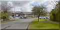
Image Map
Images are licensed for reuse under creativecommons.org/licenses/by-sa/2.0
Notes
- Clicking on the map will re-center to the selected point.
- The higher the marker number, the further away the image location is from the centre of the postcode.
Image Listing (40 Images Found)
Images are licensed for reuse under creativecommons.org/licenses/by-sa/2.0
Image
Details
Distance
1
Henry Bell Street, Helensburgh
East Montrose Street leads off to the right.
Not far from the foot of Henry Bell Street, where it meets East Clyde Street, is Image, where an artefact commemorates the same Henry Bell: Image
He is buried in Rhu (Image), but is commemorated by an obelisk here in Helensburgh (Image), and by another at Bowling (Image).
Image: © Lairich Rig
Taken: 17 Aug 2016
0.03 miles
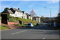
2
East Montrose Street, Helensburgh
The view is towards the junction with Image (the same junction is shown in that photograph). In the present picture, the "for sale" sign refers to Image, which had recently closed.
Image: © Lairich Rig
Taken: 17 Aug 2016
0.05 miles
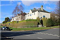
3
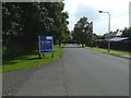
Victoria Integrated Care Centre
The centre, which is located on Image, used to be called the Victoria Infirmary.
Image: © Lairich Rig
Taken: 27 Mar 2013
0.09 miles
4
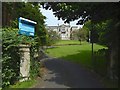
Braeholm House
The view is from Image Braeholm had closed at the end of July 2016, less than three weeks before this picture was taken.
The B-listed building had been employed as, amongst other things, a retirement home, and (what I most associate with it) a maternity hospital.
(Under the name Braeholm, the sign says "serving the naval service since 1876", which might be a little confusing; at least, it did not sit well with my own knowledge of the building's previous use. However, that tagline does not apply to the building itself, but refers instead to the year in which the charity Aggie Weston's was founded; that organisation had been operating Braeholm in recent decades.)
The building dates from about 1860. William Leiper (listed in the tags for this picture) was the architect for changes made in 1887, when a drawing room bay was added.
Image: © Lairich Rig
Taken: 17 Aug 2016
0.09 miles
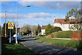
5
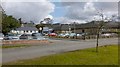
East King Street
The buildings visible ahead are the Image
Image: © Lairich Rig
Taken: 27 Mar 2013
0.12 miles
7
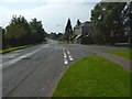
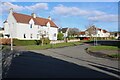
Houses on Old Luss Road
At the junction with Athole Street.
Image: © Richard Sutcliffe
Taken: 4 Mar 2024
0.13 miles
10
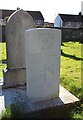
War grave - Driver Alexander Kane McConnell
T/104573 DRIVER
A. K. MC CONNELL
ROYAL ARMY SERVICE CORPS
2ND AUGUST 1941 AGE 23
HAPPY, SMILING
ALWAYS CONTENT
LOVED AND RESPECTED
WHEREVER HE WENT
Image: © Richard Sutcliffe
Taken: 4 Mar 2024
0.18 miles