IMAGES TAKEN NEAR TO
HELENSBURGH, G84 7LA
Introduction
This page details the photographs taken nearby to G84 7LA by members of the Geograph project.
The Geograph project started in 2005 with the aim of publishing, organising and preserving representative images for every square kilometre of Great Britain, Ireland and the Isle of Man.

There are currently over 7.5m images from over14,400 individuals and you can help contribute to the project by visiting https://www.geograph.org.uk
Image Map
Images are licensed for reuse under creativecommons.org/licenses/by-sa/2.0
Notes
- Clicking on the map will re-center to the selected point.
- The higher the marker number, the further away the image location is from the centre of the postcode.
Image Listing (35 Images Found)
Images are licensed for reuse under creativecommons.org/licenses/by-sa/2.0
Image
Details
Distance
1
Hermitage Academy
See Image and Image for the location of the previous building, and Image for an earlier photo of the present building. The building was probably not in use (as a school) when the present photograph was taken, on account of the local council elections held on that day.
Image: © Lairich Rig
Taken: 3 May 2012
0.04 miles
2
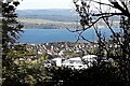
Lost Summer House
To the south east of Camis House, is a hill overlooking Craigendoran.
In 1860 the map shows the name “Summer Ho”. By 1890, the map shows just a dot.
All that remains is a ragged stone base. The length is approximate 20 metres. The Summer House was probably rotten many years ago.
There is a great view across the loch.
The Summer House was about 30 metres up from the old Ice House.
Image: © Pete Marrison
Taken: 10 Oct 2024
0.05 miles
3
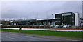
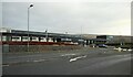
Hermitage Academy
The new school building is further east along the A814 from the old one Image
Image: © Thomas Nugent
Taken: 18 Mar 2011
0.06 miles
4
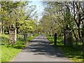
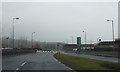
Driveway to Camis Eskan House
For the historic building itself, see Image (that photograph, by William Craig, was the first to be taken for Geograph in this square).
Image: © Lairich Rig
Taken: 3 May 2012
0.10 miles
5
Hermitage Academy
Looking across the A814 to Hermitage Academy. It is one of two Secondary schools in Helensburgh and the largest school in Argyll & Bute. The current building dates from 2008, replacing earlier buildings at Campbell Drive Image
Image: © Richard Sutcliffe
Taken: 11 Nov 2022
0.11 miles
6
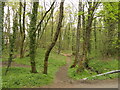
Woodland, Craigendoran Burn
A long woodland beside the burn with several paths.
Image: © Richard Webb
Taken: 26 Apr 2022
0.11 miles
7

Collins Road
View of Craigendoran's Collins Road from the woodland that once flanked the policies of Camis Eskan.
Image: © Richard Webb
Taken: 26 Apr 2022
0.11 miles
9

The Craigendoran Burn
The subject is as in Image, but the present view is downstream rather than upstream. The adjacent road (see the map) is at the top of the bank to the left.
Image: © Lairich Rig
Taken: 6 Jun 2014
0.14 miles
10
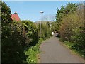
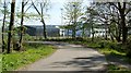
Path to Drumfork Road
The path leaves the main road near Image, and meets up with Drumfork Road at the point shown in the foreground, on the left, in Image
Image: © Lairich Rig
Taken: 3 May 2012
0.14 miles