IMAGES TAKEN NEAR TO
Charlotte Street, HELENSBURGH, G84 7EZ
Introduction
This page details the photographs taken nearby to Charlotte Street, G84 7EZ by members of the Geograph project.
The Geograph project started in 2005 with the aim of publishing, organising and preserving representative images for every square kilometre of Great Britain, Ireland and the Isle of Man.

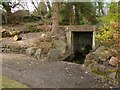
There are currently over 7.5m images from over14,400 individuals and you can help contribute to the project by visiting https://www.geograph.org.uk
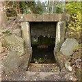
Image Map
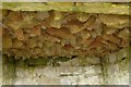
Images are licensed for reuse under creativecommons.org/licenses/by-sa/2.0
Notes
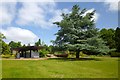
- Clicking on the map will re-center to the selected point.
- The higher the marker number, the further away the image location is from the centre of the postcode.
Image Listing (170 Images Found)
Images are licensed for reuse under creativecommons.org/licenses/by-sa/2.0
Image
Details
Distance
1
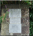
Plaques at Hermitage Park
At the corner of Argyle Street East and Grant Street.
Image: © Thomas Nugent
Taken: 10 Aug 2013
0.08 miles
2
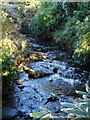
Milligs Burn
Running through Hermitage Park.
Image: © Richard Sutcliffe
Taken: 27 Jan 2022
0.09 miles
3
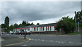
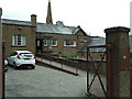
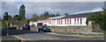
Hermitage Primary School
On Argyle Street East at Grant Street.
Image: © Thomas Nugent
Taken: 10 Aug 2013
0.09 miles
4
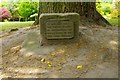
Commemorative plaque
"1910 / 1960
This tree was planted
to commemorate the
Golden Jubilee of the
Girl Guide Movement"
For a view of the tree in context, see Image
Image: © Lairich Rig
Taken: 26 Jun 2013
0.10 miles
5
Hermitage Park: the Wishing Well
This structure, the so-called Wishing Well (or Hermit's Well), is located in Image (see that picture for context), not far to the south of a walled garden (Image) that contains a war memorial (Image).
See Image for a closer look. There used to be a ladle hanging inside, but those using the well would have had to mind their heads: Image
Image: © Lairich Rig
Taken: 27 Mar 2013
0.10 miles
6
Hermitage Park: the Wishing Well
Or the Hermit's Well.
See Image and Image for context. See Image for the upper part of the interior, which is not visible from this angle.
Information panels present in the park by 2021 call this the Hermit's Well. According to http://www.helensburgh-heritage.co.uk/index.php/heritage/places/1134-the-history-of-hermitage-park (at the Helensburgh Heritage site), the well and its grotto were formed in 1914. See that link for a detailed discussion, which includes comments on the origins of the name Hermitage Park (which displaced the earlier name Cramb Park).
Image: © Lairich Rig
Taken: 27 Mar 2013
0.10 miles
7
Wishing Well: detail
See Image for the whole structure, and Image for the setting. The present photograph shows the upper part of the interior; the jagged stones were intended to give the well a grotto-like appearance. It seems also to have been known as the Hermit's Well.
Image: © Lairich Rig
Taken: 27 Mar 2013
0.10 miles
8
St Joseph's Church Hall
On Grant Street, above East King Street.
Image: © Thomas Nugent
Taken: 10 Aug 2013
0.11 miles
9
Hermitage Park
The park shelter is on the left; Hermitage House was located in that area: see Image
The tree that is prominent on the right was planted in 1960 in celebration of the Golden Jubilee of the Girl Guide Movement. The stone that bears the Image is visible just to the right of the base of the tree.
Image: © Lairich Rig
Taken: 26 Jun 2013
0.11 miles
10
Hermitage Primary School
As with many public buildings in the local authority area, the name at the door is written in English and the Gaelic. Of the two plaques at the corner of Argyll Street East one commemorates the grant of the ground, the other a noted head teacher.
Image: © Tom Sargent
Taken: 5 Oct 2008
0.11 miles