IMAGES TAKEN NEAR TO
Murroch Crescent, ALEXANDRIA, G83 9QA
Introduction
This page details the photographs taken nearby to Murroch Crescent, G83 9QA by members of the Geograph project.
The Geograph project started in 2005 with the aim of publishing, organising and preserving representative images for every square kilometre of Great Britain, Ireland and the Isle of Man.

There are currently over 7.5m images from over14,400 individuals and you can help contribute to the project by visiting https://www.geograph.org.uk
Image Map
Images are licensed for reuse under creativecommons.org/licenses/by-sa/2.0
Notes
- Clicking on the map will re-center to the selected point.
- The higher the marker number, the further away the image location is from the centre of the postcode.
Image Listing (54 Images Found)
Images are licensed for reuse under creativecommons.org/licenses/by-sa/2.0
Image
Details
Distance
1
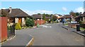
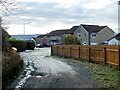
Broomhill Crescent
This is part of an area of housing called Beechwood and Wheatcroft Estates (built 1980s–90s).
Image: © Lairich Rig
Taken: 15 Sep 2011
0.10 miles
2
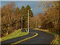
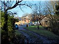
Road leading from the rugby pitch
Image: © Lairich Rig
Taken: 6 Dec 2020
0.11 miles
3
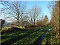
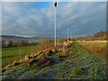
Track along the edge of Beech Wood
See Image for a view in the opposite direction from the same place. See Image for a view back from about 100 metres further on.
Image: © Lairich Rig
Taken: 28 Nov 2020
0.12 miles
4
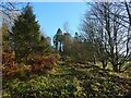
Track along the edge of Beech Wood
The track is marked on the 1:25000 map. See Image for a view from about 100 metres further on.
To the right is a field; this woodland edge is shown from across that field in Image
Image: © Lairich Rig
Taken: 28 Nov 2020
0.12 miles
5
The former site of Highdykes Farm
The site in question is, roughly, the location of the buildings slightly left of centre, that is, the ones behind the left-hand end of the fence. The farm was shown here on the first-edition OS map (surveyed in 1860) and on later maps throughout much of the twentieth century.
The viewpoint is from the point where a track first enters a built-up area, which is part of Broomhill Crescent (Image), in the Beechwood and Wheatcroft Estate.
For a view in the opposite direction from the same point on the track, see Image Followed in that direction, it leads to the current location of Image; see that picture for further comments.
Image: © Lairich Rig
Taken: 5 Jan 2021
0.14 miles
6
Track to Broomhill Crescent
See Image Followed in the opposite direction, this is a Image
As noted there, the track, if followed in the same direction as shown in the present photograph, used to lead to Image (rather than its present site, shown in Image), but the Beechwood and Wheatcroft Estate (housing), of which Broomhill Crescent is a part, now overlies that part of its former course.
Image: © Lairich Rig
Taken: 28 Nov 2020
0.14 miles
7
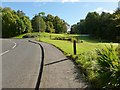
Beside the rugby pitch
Image: © Lairich Rig
Taken: 6 Dec 2020
0.14 miles
8
Road leading into Beechwood and Wheatcroft
The road branching off to the right is Image, which leads into the Beechwood and Wheatcroft Estates.
Image: © Lairich Rig
Taken: 5 Oct 2012
0.14 miles
9
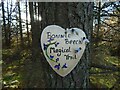
Bonnie Beech Magical Trail
In an outlying arm of Beech Wood, to the south of a Image
Image: © Lairich Rig
Taken: 13 Nov 2020
0.15 miles
10
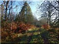
Track along the edge of Beech Wood
As Image, but from about 100 metres further on. See Image for a view in the opposite direction from the same place.
A little further on, it reaches a Image, as the map shows. Beyond that track, the woodland is called Broomhill Wood.
Image: © Lairich Rig
Taken: 28 Nov 2020
0.15 miles