IMAGES TAKEN NEAR TO
Osprey Place, ALEXANDRIA, G83 9PZ
Introduction
This page details the photographs taken nearby to Osprey Place, G83 9PZ by members of the Geograph project.
The Geograph project started in 2005 with the aim of publishing, organising and preserving representative images for every square kilometre of Great Britain, Ireland and the Isle of Man.

There are currently over 7.5m images from over14,400 individuals and you can help contribute to the project by visiting https://www.geograph.org.uk
Image Map
Images are licensed for reuse under creativecommons.org/licenses/by-sa/2.0
Notes
- Clicking on the map will re-center to the selected point.
- The higher the marker number, the further away the image location is from the centre of the postcode.
Image Listing (74 Images Found)
Images are licensed for reuse under creativecommons.org/licenses/by-sa/2.0
Image
Details
Distance
1
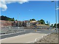
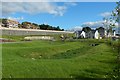
Construction of Mill Fields
The roundabout is recent (Image); the houses being built behind it are even more so.
Image: © Lairich Rig
Taken: 18 May 2017
0.02 miles
2
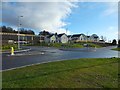
The Mill Fields development
This is the southern part of the site; the nearest building is the show home. For the northern part, see Image
Click on the end-note title for related pictures.
Image: © Lairich Rig
Taken: 11 Feb 2018
0.03 miles
3
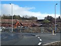
Construction of Mill Fields
The view is from beside a new roundabout (Image). The sloping ground (shown before construction in Image) has been laid out in terraces.
Image: © Lairich Rig
Taken: 20 Feb 2017
0.03 miles
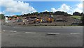
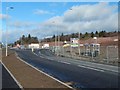
4

Mill Fields, Bonhill
Mill Fields built by Barratt Homes on Stirling Road, Bonhill, ALEXANDRIA, WEST DUNBARTONSHIRE. looking South toward Osprey Place, with Kingfisher Avenue on the top left.
Image: © George Rankin
Taken: 6 Aug 2019
0.03 miles

7
Mill Fields: southern end
Work was still taking place on the upper level; compare Image
Image: © Lairich Rig
Taken: 4 Sep 2018
0.04 miles
8
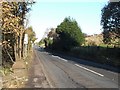
Stirling Road
A footpath to a nearby industrial estate begins at this point: Image
Image: © Lairich Rig
Taken: 31 Oct 2008
0.04 miles
9

Lady's Gate, Strathleven Estate
This is a view from the southern end of the street. Directly behind the photographer's position is a meadow crossed by a footpath; in fact, the photograph was taken from the edge of the meadow, which is shown in Image and Image
Not far away is Image
Image: © Lairich Rig
Taken: 14 Nov 2010
0.04 miles
10
Construction of Mill Fields
Stirling Road is in the foreground. The junction that can be seen ahead, on the left, was present before construction work began, but the roundabout is new.
Image: © Lairich Rig
Taken: 20 Feb 2017
0.05 miles